Полная версия:
The Sea Coast
The growth of certain shingle spits and forelands can be traced with some approach to accuracy over long periods. Orford Ness illustrates the point well. In 1601 it was carefully mapped by Norden, who made a survey of the whole Manor of Sudbourne. The maps are on a large scale and the spit itself seems to have been as carefully surveyed as the farm land. Figure 7c shows the position of the south end of the spit in 1601. We know that, apart from minor setbacks, the spit lengthened until it reached a maximum in 1897, in which year a great storm did much damage along the east coast, and cut off about a mile of its distal end. Since then its history can be traced from various editions of the Ordnance Survey. Before 1601 the evidence is far less reliable. There is in the British Museum an Elizabethan map which is undated, but probably was made about 1590. It shows a considerable amount of detail, and the southern tip of the shingle bar is marked opposite a point nearly half-way between Boyton Hall and Cauldwell Hall. A map by Appleton (1588) is similar, and in fact may have been copied from the other map, or vice versa. Both show the Alde above Aldeburgh wrongly orientated. Saxton’s (1575) and Speed’s (1610) maps are sketchy as far as the coast is concerned, and do not help us at all. Maps of the seventeenth and eighteenth centuries show the gradual southward progression of the spit, and in a broad sense are consistent with the later maps and the first Ordnance Survey map of the district, dated 1805. From that time we have fairly reliable data.
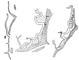
FIG. 7 Orford Ness. (a) Part of Coastal Chart said to be temp. Henry VIII; (b) Map, temp. Elizabeth; (c) Norden's Map, 1601. The position of Orford Castle is shown on the two earlier maps. See also Fig. 36
The earliest map of this part of the coast is part of a chart extending from Gorleston to the Orwell, and may have been prepared in connection with coast defence schemes. It is an attractive but rather imaginative piece of cartography, and marks the entrance to Orford Haven close to what we now call Stonyditch Point. It is not a map from which we can make measurements. It carries no date, but there is some reason for supposing that it appeared about 1530. Granting that, and assuming that the end of the spit was then more or less in the place suggested by the map, we can only conclude that the spit grew with great rapidity between 1530 and 1601 (Norden). But by Henry VIII’s time the prosperity of Orford had declined: its rise had corresponded with the building of the Castle in 1165 when “shingle had begun to collect at and upon the headland, Orford Ness. The town quickly developed from the small hamlet of Sudbourne to a thriving port, and finally to a flourishing borough standing at the very mouth of the haven.”1 This last statement is significant. When the shingle of the Ness had reached the neighbourhead of Stonyditch Point it would form a protection to the port of Orford. Moreover, an inspection of Stonyditch Point today shows that a number of shingle ridges end there, implying that for a considerable time the mouth of the river was approximately in that position. If this argument is sound, the Henry VIII map, which in any case is a kind of picture of the coast rather than a map in the ordinary sense, represents the coast much as it was in Henry II’s time—at the period when the Castle was built and Orford was at its zenith. The gradual decay of the town is intimately linked with the menace of the ever-growing spit, but other factors have, of course, also played a part (see Fig. 36).
Orford is a spectacular example, but similar histories apply to other east coast havens, including Southwold and Yarmouth. The smaller havens of past times at Benacre and Thorpe have been completely blocked by shingle. On the Norfolk coast the westward growth of Blakeney Point was one of the main factors that led to the decay of the combined port of Blakeney-Cley-Wiveton. In a Muster Roll of 1570 these three ports exceed King’s Lynn both in number of ships and mariners, and in 1582 a record shows that they jointly possessed seven ships of more than 100 tons, whereas Lynn had two and Yarmouth four. In these and all similar cases, the growth in the size of ships was a main factor in the decay of shallow water ports. Moreover, the final blow to the small ports of North Norfolk occurred when the railways were built. Even at Thornham, now truly derelict, corn was exported and coal imported almost within the memory of some still living.
Many ports and harbours on other coasts tell a similar tale, but seldom have we reliable evidence of coastal changes and evolution. Edward I built his castle at Harlech in 1286. Since it has a water-gate, it presumably at one time had easy access to the sea. There is no known document which illustrates the condition and nature of the coastline when the Castle was built. There are, however, several references in the Public Record Office that make it clear that Harlech was a port, and that the actual harbour was probably at, or very close to, the Castle (see Fig. 28). Today the Castle on its rock is well back from the sea. The whole area of Morfa Harlech has been photographed from the air, and a careful inspection of the mosaic and a study of the shore processes and features of this part of Cardigan Bay indicate that what is now Morfa Harlech began its growth as a small shingle and sand spit south of Harlech. Growth to the north continued, and in 1808 the marsh within the spit was embanked. From what can still be seen, and also from inference, creeks of some size intersected the marsh, and the havens and creeks so often referred to in the documents dealing with Harlech, may well have been those in the marsh which developed pari passu with the growing spit, which in 1286 had grown only a little so that ships could easily sail round it and come into the harbour it enclosed. After the conquest of the Welsh, and as a result of the constant growth of the spit, Harlech as a port declined in importance. It is more than likely that for some time small ships could still sail round the northern end of the spit into calm creeks within, but a time came when this was difficult, and the final embanking rendered it impossible.1
Another form of rapid change in coastal areas occurs where dunes are advancing. The full history of this subject is difficult and complicated, since in some cases, at any rate, it may be interconnected with slight vertical changes in the relative levels of land and sea. In South Wales there are extensive expanses of dunes, and Higgins2 has made a careful investigation of their growth. There are many instances of encroachment of dunes over settlements and farm lands. The Via Julia, dating from the first century A.D., may have passed through what is now the north-eastern corner of Kenfig Burrows. The local settlement was probably in use by the end of the ninth century. There was certainly a castle in 1152, and the port was in use in 1184. The church dates back to before 1154. The new, i.e. Mawdlam church, was built on higher ground in 1261, and Kenfig Pool existed in 1365. The old church was used until 1397, and the Via Julia was open until 1344, and the Castle occupied until 1403. Later, the site was obliterated by sand. “The evidence … makes it clear that in this region there was no apparent danger from moving sand at the close of the twelfth century, but that within a hundred years the sand in the immediate vicinity of the town itself was a danger, and that by 1485 moving sand was affecting the area beyond the town ….”1 This was typical of other dunes in South Wales, and Higgins finds the evidence throughout reasonably consistent. No danger from moving sand seems to have been noticed up to the early part of the thirteenth century. There was a fairly sudden change in the fourteenth, and the records all seem to suggest that these storms blew up much sand, which greatly damaged property and agricultural land. We know that not only here but elsewhere the thirteenth and fourteenth centuries were times of great storminess, and that changes in coastal areas were then often considerable, especially in the Low Countries. It still remains to be proved whether this period was one in which a slight change of level, strongly suspected in Romney Marsh, also took place.
In Cornwall, too, there is plenty of evidence about the movement of sand and the burying of churches and other buildings. We may illustrate the matter with reference to Perranzabuloe. Dexter2 has sifted fact from fiction and we cannot do better than follow him. The legend of the Three Churches is this: Long ago a great sandstorm overwhelmed the parish of Perranzabuloe (Sanctus Piranus in Sabulo). The oratory or shrine of St. Piran was buried and lost for centuries. It was accidentally unearthed about a century ago. With the burying of the shrine (i.e. the first church), the parishioners built a second, which also suffered a similar fate, but since the threat was anticipated the parishioners took down this second Church stone by stone and re-erected it as the third church at Lamborne. Only the foundations of this second church were left in the sandhills, and a cross was set up to mark its site.
So much for legend; excavation and analysis have produced the facts. The Oratory was built at the head of a little fertile combe in the sixth or seventh century. It is not quite certain if St. Piran actually built it. It was an Oratory and not a parish church. Gradually accumulating sand caused the adjacent spring to change its course so as to threaten the western wall of the Oratory; consequently, a stone dam was built, probably during the eleventh century. The relics of St. Piran were enshrined here, and the Oratory became a mediaeval pilgrims’ shrine. For this reason another doorway was made, and a new one substituted for the original Celtic doorway. This alteration was probably finished in the twelfth century. Up to the time of the Reformation the Oratory was kept clear of sand so that the relics of the saint could be seen. But when the destruction of shrines and images took place, the Oratory roof was removed. This was early in the reign of Queen Elizabeth. The Oratory was thus neglected and was gradually surrounded by sand. Yet Camden, in 1586, speaks of it as “on the sands,” and Wilson1 says it could still be seen in 1608. Soon after this the sands covered it, and it was lost, until in 1789 the shifting sands again exposed the western gable. In 1835 it was excavated by William Michell, and by William Haslam in 1843. Then it was neglected until 1892, and finally excavated and partly restored in 1910.
The Old Parish Church was built between the ninth and eleventh centuries, about one-third of a mile east of the Oratory, in order to avoid the encroaching sand. Part of this building still survives, and it is to it that the Domesday survey refers. Additions were made to this Church in the twelfth and fourteenth centuries. Up to the beginning of the seventeenth century, it was free from sand, but then mining operations diverted the stream which flowed between it and the Oratory—this stream had been a means of checking the sand advance—so that the original stream bed dried up and sand began to threaten the church. For the next two centuries various attempts were made from time to time to restrain the sand, but eventually it prevailed. Parts of this church were removed, but most of it was left, and it was still visible in 1848. The present church was consecrated in 1805.
Other coastal areas of north Cornwall were also ruined by sand. The Gwithian sands cover about the same area as do those at Perranzabuloe, and seem to have formed in the Middle Ages. In the seventeenth century they were a menace, and Lelant Church was invaded. East of the Hayle river these sands caused the deterioration of a considerable area of good agricultural land. Somewhat similar, but less extensive damage was done by sand advancing on to farm land south of Trevose Head. St. Constantine’s Chapel was also destroyed. North of the Camel estuary is an extensive dune area at St. Minver. These dunes were threatening St. Enodoc’s Church in the first decade of the nineteenth century, and finally ruined it.
In all these cases there is an obvious parallel with South Wales. The present dune areas were, as far as the very slender evidence goes, quite free from sand in the sixth and seventh centuries.
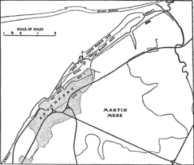
FIG. 8 Coastal changes at Southport. (From information supplied by Borough Surveyor)
By the thirteenth and fourteenth centuries dunes became a serious menace. There was apparently a more stable period in the sixteenth century, and a renewed advance later.
Southport illustrates admirably the growth of a modern town on recent accumulations of blown sand. A map dated 1736 shows the site of Lord Street, the chief thoroughfare of the town, as “The New Marsh,” and washed by high tides. By 1834 a new range of dunes had formed to seaward, and “Lord Street” was then a line of slacks or fresh-water pools. Extensive reclamations were later carried out, including the extension to the North promenade, and the building of the Marine Lake and Marine Drive in 1887–1895. The last sea-bank around the Municipal Golf Links was made in 1931–32. In the Crossens district (the north-west end of Southport) considerable changes have taken place, and are shown in Figure 8. In recent times reclamation in this part has been carried out by the planting of a stretch of fore-shore below high-water mark with grass sods, or samphire, set out at about one yard intervals. These gradually grow together to form a close turf, and the level also rises with the deposition of tidal silt. When conditions are judged fit, an embankment is built to exclude the sea, and the reclaimed area is drained. In the southern part of the town and nearer Birkdale the coast has altered far less. There has been some outward growth since the coast at one time followed what is now Rotten Row.
What has been said so far shows that even during the last two or three centuries it is far from easy to make any exact assessment of coastal changes. They are known quite well qualitatively, but not quantitatively. It is only occasionally that we find reliable data which allow us to fix details with certainty. In still earlier times the record is worse, and before the period of maps and plans we have to rely on descriptions and perhaps tradition. Sometimes we can check this evidence by careful archaeological or geological excavations, but even so we seldom if ever get precise measurements except at the place of excavation, and even there the evidence is sometimes equivocal.
In Wales, Cornwall, Ireland, and Brittany there are many legends which have as their theme the overflowing of wells or lakes or the drowning of low-lying areas by the sea. In the Isles of Scilly and the neighbouring parts of Cornwall there is the legend of Lyonesse—the fertile land that formerly was supposed to extend beyond Cornwall. This land was alleged to have been overwhelmed by the sea, leaving but one survivor, a man named Trevilian, who was able to mount a swift horse and escape to the mainland. Geological and perhaps archaeological evidence certainly supports the view that land has been comparatively recently submerged in the Isles of Scilly, and although this submergence may have included the rocks called the Seven Stones, mid-way between the islands and Cornwall, there is no ground whatever for the tradition that these rocks mark the site of a large city.
Off Penmaenmawr in North Wales there is visible at low water a patch of seaweed-covered stones called Llys Helig. These have been described as the ruins of a palace which was inundated between the fourth and ninth centuries. It has been conclusively shown1 that this story is only about a hundred years old, but it is nevertheless often regarded as history based on the authority of “An Ancient Survey of Pen Maen Mawr” by Sir John Gwynn, who, in turn, refers to earlier “authorities.” According to the Survey, Helig and his people, when the supposed sudden inundation took place, fled to Trwyn ‘r Wylfa, a hill in the parish of Dwygyfylchi, which is still sometimes referred to as the Hill of Mourning. But recent examination of the legend and also of the site of Llys Helig, has shown that the legend is a fairly modern tale, and that the palace is nothing else than a heap of large stones—the remains of a former glacial deposit, similar to the scars so frequently found on the Cumberland coast.
The most interesting example illustrating the inter-relation of physiography, geology, archaeology, and folk lore is to be found in the legend of Cantref y Gwaelod. In Cardigan Bay there are several Sarns, or causeways, running seawards from the coast. The longest is Sarn Badrig, or St. Patrick’s Causeway, which runs south-west from Mochras Island for about twenty miles, nine of which may be exposed at a very low ebb. The others are shorter: Sarn y Bwch is about a mile long, Sarn Cynfelin seven or eight miles, Sarn Dewi about a quarter of a mile, and Sarn Cadwgan one and a quarter miles long. They are all formed of loose rounded stones and boulders and are quite narrow. Tradition has it that some of them represent the remains of masonry. This, however, is false; they are entirely natural features.
The first mention of the lost land, or lost hundred, of Cantref y Gwaelod occurs in the so-called Black Book of Carmarthen, which belongs to the twelfth century. There the cause of the flooding is ascribed to one Margaret or Meredig “who, at times of feasting, allowed the water of a magic well, under her charge, to overflow the country.” The more popular tradition blames a certain Seithennin, who, in his cups, neglected the sluices. In course of time the legends varied, but Seithennin remains the central figure. In 1662 this story was connected with Sarn Badrig by Robert Hengwrt. Later writers embellished this suggestion, and in the eighteenth and nineteenth centuries there was a collection of tales and legends to the effect that Cantref y Gwaelod had been drowned in historic times as a result of carelessness. Hence, it is not surprising to find that an actual date is ascribed to the event, namely A.D. 520. There is no historic support for this. The Romans did not occupy any of the coastal area between 55 B.C. and A.D. 409, and no mention is made either of the lost land or of the catastrophe in Antonine’s Itinerary, or by Ptolemy, or by Giraldus Cambrensis.
Is there, then, any foundation for the inundation legend? Certain facts are important. The sarns are natural features; at Borth and other places there are submerged forests indicating changes of level; this and the existing distribution of boulder clay on and near the coast clearly imply that much of Cardigan Bay was a low lying boulder clay plain before a geologically recent subsidence or submergence took place.
Somehow or other it seems that a tale of a former land in Cardigan Bay has come down to us from remote antiquity, and it is one of many similar tales. “The numerous interesting features which these tales have in common seem to suggest the existence in past times of people who were supposed to live in lakes, were small of stature, disliked iron, possessed few articles of furniture, had not learnt the art of making bread, disliked the greensward being broken up by the plough, were successful in tending animals, had a limited ability to count, and probably used a language of their own which no-one else understood. They appear also to have reckoned descent in the female line. If this suggestion is accepted, these characteristics are consistent with a pastoral people in a primitive state of culture, who were not acquainted with the use of iron, but who attributed great importance to stocks of cattle, sheep and goats, and knew little or nothing about tilling the ground and the growing of corn.”1
This description might well apply to the Bronze Age people, whose pile-dwellings make clear their intimate association with lakes. The later Iron Age peoples, with better weapons, must have frightened the earlier inhabitants. An anthropological investigation of Central Wales has revealed that a short, dark, and rather long-headed people are associated with remote hill lands, in fact in places where traces of Neolithic man are still common. In the Mawddach valley, around Towyn and in other places is another type. In these places Bronze Age pottery is found. The distribution of these people suggests they came later than the dark hill folk. Later still came the iron using people.
It is, therefore, possible that the folk tales, a better description than legends, go back at least as far as the early contacts of the Iron Age people with the peoples already living in Wales, or it may even be that the tales date from the remoter past when the Bronze Age and Neolithic peoples were first in contact.
There is little doubt (see Chapters 8 and 9) that in or before the Neolithic period the boulder clay reached some distance out into Cardigan Bay as a low-lying plain through which the rivers pursued winding, sluggish courses. The post-glacial rise of sea level included the Neolithic period, but probably ceased fairly soon after it. It is likely that the submergence was wholly or nearly complete in the Bronze Age. It has been argued with conviction that many of the present inhabitants of Wales are the direct descendants of Neolithic man, and it is at least possible that their remote ancestors actually witnessed the drowning of the coastal plain. In short, we may have in the legend of Cantref y Gwaelod the gist of a folk tale that has been handed down from a very remote period of human history.
One final word: the sarns are formed of boulders that were contained in the boulder clay; there is no reason whatever for ascribing their formation to any human element. It is, however, difficult to account for their long and narrow shape. Sarn Badrig and Sarn Cynfelin occur about mid-way between river mouths, thus suggesting the idea that they are in some way continuations of the watersheds between adjacent streams.
1 For recent information on Holderness I have made considerable use of an unpublished report, 7 July 1947, by G. M. Hines and C. Pinsent, Research officers to the Ministry of Town and Country Planning (Leeds), and shown to me by the kindness of the Regional Controller.
1 The Lost Towns of the Yorkshire Coast,” 1912, p. 42.
2 It was later removed.
3 Letter 10.9.1948 from the County Planning Officer (Norfolk) to the Regional Controller, Ministry Town and Country Planning, Cambridge.
4 The figures are kindly given to me by the Cambridge office of the Ministry of Town and Country Planning.
1 Partly from a plan prepared by F. W. S. Stanton about 1908, and further details from information supplied to the Ministry of Town and Country Planning (Tunbridge Wells), and passed to me by Mr. H. R. Wardill.
1 Based on information given to me by the Department of Health for Scotland.
2 Halophytes are plants which will live in soils containing an appreciable amount of common salt or of other organic salts.
1 C. P. Petch, Reclaimed Lands of West Norfolk, Trans. Norf. Norw. Nat. Soc. 16, 1945, 106.
2 A. G. Tansley, The British Islands and their Vegetation, 1939, p. 828.
1 Royal Commission on Coast Erosion and Afforestation: Final Rept. p. 135, para. 49.
1 V. B. Redstone, Memorials of Old Suffolk, Ch. XII. (The italics are mine, J.A.S.).
1 An account of the historical fluctuations of the bar of the river Findhorn, on the Moray Firth, is given on page 143. All river harbours deflected by a sand or shingle bar have similar stories, but the examples given are sufficient to illustrate the general subject.
2 Arch. Cambrensis, June, 1933.
1 L. S. Higgins, op. cit.
2 A Cornish Legend: the Three Churches of Perranzabuloe. Truro, City Printing Works, 1923. Dr. N. J. G. Pounds put me in touch with various sources dealing with coastal sand areas in Cornwall.
1 The English Martyrologe, 1608, p. 116.
1 F. J. North, Supplement to the Llandudno, Colwyn Bay and District Field Club Proceedings, Llandudno, 1940.

