Полная версия:
The Sea Coast
The bizarre features of granite weathering, partly marine, partly subaerial, are remarkably displayed in the Isles of Scilly, which are wholly granite islands, probably at one time part of a larger mass like Bodmin Moor, or any of the other granite masses of Cornwall and Devon. They are now partly drowned, and subjected to powerful marine erosion. The sea has eaten into joints and other planes of weakness and together with subaerial weathering has produced curious features resembling great blocks roughly piled upon one another. Their surfaces are clean, but rough in detail owing to the differential rates of erosion of the various minerals of which the granite is composed. Sometimes the surface of the large blocks may be hollowed out into kettles and pans; in other places weathering and marine erosion may produce spiky forms. Often large slabs are left projecting or overhanging. In the lower parts where the cliffs, in the ordinary sense of the word, are insignificant or even absent, the outlines may be most irregular. The granite readily breaks down into sand, and bayhead beaches and tombolos are common. There are also cracks, running generally a little west of north. These are most conspicuous on the northern shores, where the Atlantic waves eat out the crushed granite along them. There is reason for thinking that these cracks are a result of the latest movements which have affected the granite, but they definitely have a great influence on the configuration of the islands as a whole, and of the waterways leading to the Interior sea.
In some islands, especially in Great Ganilly, there is a series of vertical cracks along which there has been some alteration of the granite. These cracks are often referred to as Greisen1 lines. They are also easily eroded by the sea, which has locally cut deep inlets along them. An example occurs at the south end of White Island (St. Martin’s); the inlet is extremely like a geo. On a bigger scale the effect of erosion along these fines is seen in the long inlets near Old Town, St. Mary’s.
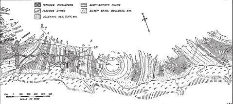
FIG. 17
Coast platform showing Sedimentary Structures and Igneous necks between Kinkell Ness and Kingask, Fifeshire. (After S. R. Kirk)
Конец ознакомительного фрагмента.
Текст предоставлен ООО «ЛитРес».
Прочитайте эту книгу целиком, купив полную легальную версию на ЛитРес.
Безопасно оплатить книгу можно банковской картой Visa, MasterCard, Maestro, со счета мобильного телефона, с платежного терминала, в салоне МТС или Связной, через PayPal, WebMoney, Яндекс.Деньги, QIWI Кошелек, бонусными картами или другим удобным Вам способом.
Вы ознакомились с фрагментом книги.
Для бесплатного чтения открыта только часть текста.
Приобретайте полный текст книги у нашего партнера:
Полная версия книги
Всего 10 форматов

