Полная версия:
The Sea Coast
There have been several other slips in this neighbourhood, all of which were similarly caused. Another example of major slipping is found at Folkestone Warren. Various ideas have from time to time been put forward to explain these slips, but the most recent views of W. H. Ward2 are interesting. His sections show that the slips are primarily caused by the erosion of the Gault toe by the sea, and that the slips are rotational (i.e. turning about a horizontal axis) in character. The plane on which slipping takes place penetrates the full thickness of the Gault, and there is no suggestion that the Chalk is sliding down the surfaces of the Gault. Ward is also of the opinion that the Axmouth slip was rotational.
There are many other examples of local slipping, including the Tertiary beds of the Isle of Wight facing the Solent, and the undercliff near Niton in the south of the Island. Landslips include a wide variety of phenomena from the great slip at Axmouth to the almost constant loss of sand and fine pebbles that takes place on the high cliffs at Beeston and Skelton Hills, near Sheringham. This constant loss is not a landslip in the normal sense of the word, but any slide forward or downward, whether big or little, ought to be included.
This chapter began with some reference to the development of the profile of cliffs. It would have been perhaps more logical to have followed or preceded that section by a consideration of the structure in plan. But it is difficult to deal in strict sequence with a series of topics of which the effect, or the application, of all may take place concurrently.
When the sea abuts against a land mass, no matter what the form of that land may be, it begins to attack it, and naturally the weaker rocks suffer most readily. A great deal, however, depends upon the arrangement of the strata in relation to the sea, in other words, on the structure of the land mass.
In the early stages, the waves will make the coast more irregular than it was initially, since they are cutting and trimming all the more easily removed parts. In course of time the waves smooth and round off projections and with the material thus produced cut cliffs and build beaches. It is sometimes contended that beaches of various kinds are best developed in the youthful stages of shoreline evolution, and that as time goes on the coast is more and more simplified so that the original great variety of beaches gives way to simplicity or even monotony. Text-books sometimes depict the various stages of evolution as in Fig. 10a, b, c, d. This evolutionary view is broadly correct, but the diagrams are only of general appplication.
Perhaps the nearest equivalent in these islands to the type of coast illustrated in Figures 10a, b, c, d is that of south-western Ireland,1 or, on a smaller scale, the coast of Pembrokeshire.1 Both these may be regarded as in the stage of youth. Another stage intermediate between 10c and 10d is represented by the coast between Start Point and the River Dart (Fig. 11).
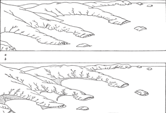
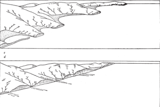
FIG. 10—Diagrams illustrating the theoretical evolution of a coastline of submergence. Modified from W. M. Davis (From P. Lake, Physical Geography, 1949)
The rocks are relatively soft, and smooth shingle and sand beaches occur at Bee Sands, Hallsands, Slapton, and Blackpool. The coast between Speymouth and Rosehearty on the Moray Firth is an example of one formed of hard and often metamorphic rocks, all much folded. The folds run almost at right angles to the coastline and the detail is crenulate in pattern. Along east Norfolk and Suffolk the cliffs are composed of Pliocene Crags and more recent gravelly and sandy beds which physiographically differ but little from the crag. All are soft and the sea has cut back and regularised the coast, and built beaches which may dam back the small streams or deflect the larger ones. The same type of coast occurs in Essex, but at first sight it looks very different because marine forces have so far not been able to build bars of sand or shingle across the river mouths, and the coast remains decidedly irregular. This contrast is worth bearing in mind, because useful though schematic diagrams are, they often give somewhat misleading ideas, especially if an attempt is made to fit them to an actual stretch of coast.
A distinction is usually made between submerged and emerged shorelines, and perhaps neutral shorelines may also be added as a separate class. Theoretically this is sound; but in practice it is not always so easy to apply the terms, or rather to say that a particular sequence of events is characteristic of either submergence or emergence. A land mass sinking down so that the waves come to rest against a contour line is more than likely to have an irregular shoreline, whereas a shoreline resulting from the uplift of part of a shallow sea floor will probably be fairly simple in outline, especially if deposition has had time to blot out any irregularities that may have existed.
In a general way it is true to say that throughout these islands the coastline is a submerged one. But it is not so merely as a result of one particular movement of land or sea which brought the sea against the land at the present level. Even now (Chapter 9) there is slight movement still in progress. Our shores are submerged mainly on account of the rise of sea level in post-Glacial times. There is every reason to believe that immediately after the Ice Age, sea level was about 200 feet lower than at present. But it also follows that since the Ice Age was characterised by more than one advance and retreat of the ice, the sea level before, during, and after the Glacial period must have fluctuated considerably. Hence, our coasts have been alternately uplifted and depressed relative to sea level, and it by no means follows that they are back at precisely the same height at which they stood in pre-Glacial times.
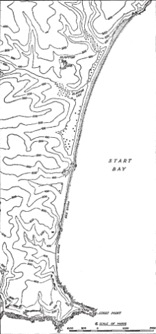
FIG. 11 The Coast between Start Point and the River Dart. (Based on Ordnance Survey)
Since effective cutting back of a coast by marine erosion implies a Fair degree of exposure to wave attack, and so to open sea, it follows that many miles of the more sheltered parts of the western coast and islands of Scotland, intricate though they may be in detail, owe little if any of their outline to wave action (see here). On the other hand, softer rocks in fairly sheltered positions yield quickly. Along our south and east coasts the main wave attack is somewhat oblique to the general trend of the coastline. It is, however, along these coasts that the effects of differences in the hardness of the rocks are well seen. The old and hard rocks of much of Cornwall and Devon yield but slowly, and the coast from Start Point right round the Lizard and Land’s End and north-eastwards to perhaps Hartland Point can be regarded, in plan, as in a young stage of development. But even in this long stretch it is interesting to note how the hard igneous rocks often form capes and headlands. The same is true, but on a smaller scale, of that part of Pembrokeshire between St. David’s and Strumble Head, where it is astonishing how intimate is the connection between the details of the coastline and rock type.
Along the Channel coast the Mesozoic and Tertiary rocks of the Hampshire Basin, Isle of Wight, and the Weald produce an irregular coast, which may run parallel with the folds as in the south of the Isle of Purbeck, or cut directly across them on the east and west of the Isle of Wight, or truncate them obliquely as in the eastern Weald. Taken broadly, the south coast shows a fairly smooth, even outline in marked contrast to the intricate pattern of Devon and Cornwall, because the sea has been able to wear back the rocks and make sweeping lines of cliffs. Beach material travels along the coast and forms smooth beaches at the foot of cliffs, deflects bigger streams by shingle bars, and blocks little brooks, and at Dungeness and other places collects in great shingle forelands, the seaward sides of which show smooth and sweeping outlines.
There is no need to discuss further examples of the evolution of the coastal plan in this chapter; they are more appropriately dealt with in other contexts.
1 See page 260.
1 Geogr. Journ., 114, 1949, 191.
1 It is not implied that, even if this is the case, the present cliffs represent actual fault scarps. They may perhaps be regarded as fault-line scarps,
2 Along much of the Durham coast the cliffs are not of modern origin in the sense of being formed wholly by the sea at its present level. Low flats occur in front of several Unes of cliff, and stacks wholly or partly above present sea level are found on them.
1 E. A. N. Arber, The Coast Scenery of North Devon, London, 1911. See also W. G. V. Balchin, Trans. Roy. Geol. Soc. Cornwall, 17, 1946, 317.
1 In northern Scotland geo, or sometimes goe, is a term applied to a deep and narrow inlet, usually with steep sides, and cut in hard rock. They are extremely well developed in the Old Red Sandstone of Kincardine, Caithness, and the Orkney Islands. The voes of Shetland are somewhat similar.
1 M. A. Arber, Proc. Geol. Assoc., 51, 1940, 257.
2 Geogr. Journ. 105, 1945, 170.
1 The major features of the coastlines of south-west Ireland and Pembrokeshire are the result of drowning; local details are the result of erosion or accretion.
CHAPTER 5
CLIFF SCENERY

COASTS FORMED OF IGNEOUS ROCKS
Coasts formed mainly or wholly of rocks of igneous origin differ greatly not only from those formed of stratified rocks, but also amongst themselves. This is largely because there is a wide variety of igneous types, but still more because these rocks occur in many different ways. There is, for example, no similarity between the granite coast of Land’s End and the tuffs and agglomerates associated with the old volcanic vents on the coasts of the Firth of Forth,
Magnificent examples of shore forms associated with lava flows, dykes, and sills are seen in the western islands of Scotland. In south Arran the country rock (Triassic sandstone) is pierced by numerous vertical dykes which run out from the cliffs across the beach as a series of low ridges from a foot or two up to several yards in width. Since they are usually harder than the rocks they intrude, the dykes stand above the general level of the beach, but here and there the converse occurs. They may act rather like groynes, and sometimes trap material travelling along the beaches. It is plain on Fig. 13, that these dykes are part of a great system associated with five main centres in western Scotland—Skye, Rum, Ardnamurchan, Mull, and Arran—and other centres in north-eastern Ireland. Detailed geological maps show numerous dykes along certain tracts of coast (see Fig. 14).
Whereas the dykes give great character to the shore platform, they also play some part in the configuration of the cliffs. Often they form great buttresses, sometimes they make re-entrants. They may reach to the top of the cliffs. But the great lava flows and interbedded agglomerates are the features which commonly play the greatest role in cliff scenery in the wholly volcanic areas. Many excellent examples occur. In Canna, the high cliffs at Compass Hill are formed of bedded tuffs and agglomerates alternating with sheets of columnar dolerite. The north coast of Canna is faced by a line of black and nearly perpendicular cliffs. Unfortunately their northern aspect obscures their beauty. The whole island consists of lavas and sills, and a line of fine cliffs also faces west. The other parts of the coast are lower. The bright green appearance of the interior, the lines of interior cliffs and the frequency of columnar structures, make this small island most attractive. Muck is generally similar (Fig. 12).
Eigg, too, presents some striking features. The northern part, indeed nearly the whole island, is formed of basaltic lavas. In the north they rest on Jurassic sediments which give grassy slopes and make the lower ground around Cleddale. The north-east is thus a high plateau, sloping upwards to the north, and breaking off to the west, north, and east very abruptly.
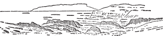
FIG. 12 Dykes on the Coast of Muck. (After A. Harker)
The great lava flows, often markedly columnar, give a strongly terraced appearance to the island. Along the east coast steep slopes reach sea level, but there are no true erosion cliffs. The Sgurr is the most spectacular feature of the island. From the north it appears as a great perpendicular monolith. By sailing round the island one can obtain a reasonable appreciation of this interesting feature. It is a long line of whitish rock running parallel with the south coast, and ending in fine abrupt precipices to the southwest. It is a great sheet of pitchstone, the origin of which is still debatable. Harker concluded it was an intrusion, whereas Sir A. Geikie, and more recently Sir E. B. Bailey, consider it as a series of subaerial lava flows filling a valley eroded in the basalts (Fig. 15).
In western Skye are some of the finest precipitous cliffs in lava in these islands. At Talisker the flows vary from 6 or 8 feet to 40 feet in thickness. At Dunvegan Head, about 1000 feet high, there are at least 25 sheets averaging about 40 feet thick. Perhaps the best development of a basaltic coast occurs between Loch Bracadale and Loch Brittle.
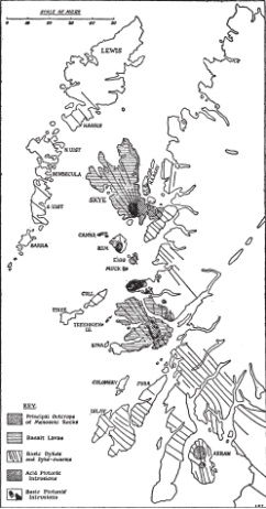
FIG. 13 Igneous Rocks in the Western Isle and mainland of Scotland (Based on Geological Survey)
In this stretch the basalts descend below sea level and give rise to a great range of precipitous cliffs, often nearly vertical, and ranging from 500 to even 900 feet high, the maximum being reached at Beinn nan Caithearn. Since the cliffs are formed of lava flows and sills, they bear a close resemblance to stratified rocks. The sills, which are markedly cross-jointed, are here no more resistant than the lavas, and so the whole shows one great face.
On the eastern coast of Skye the Jurassic rocks are below the basalts. But the great sills, often exceeding 100 feet in thickness, which penetrate these rocks, also strengthen them, and allow them to form prominent cliffs. The higher basalts often form another, inner line of cliffs, behind, and roughly parallel to the actual sea cliffs. The varying thickness of the sills, their inclination and their local frequency give much variety to the scenery. In general, the sills are harder than the lavas, and so they stand salient.
If in any locality the inclination of the sills is but slight, flat-topped hills may be formed. MacLeod’s Tables, west of Dunvegan, illustrate this. If a sill is steeply inclined, and divides the summits into sharp steps where columnar jointing is marked, a vertical element enters into the scenery, and often in such places detached masses and pinnacles stand out from the general line of the cliffs. Sometimes this is also true of dykes, but very often in Skye the dykes weather more rapidly into hollows. This is not because they are formed of softer rock, but, in Harker’s opinion, because of the vertical posture which makes attack easier; “and this is most markedly the case where a multiple dyke has presented several vertical planes of weakness … in a short space. Any tendency to a platy fracture in an undivided dyke tells in the same sense, and the much commoner cross-jointing also facilitates disintegration by allowing the dyke to divide into little horizontal prisms which are easily removed.”1
Probably the best-known example of columnar lava in western Scotland is at Fingal’s Cave on Staffa. The lava in the cave and along much of the west coast of the island is underlain by a red ash, and at Meallan Fulaan it passes under other basaltic flows. At Fingal’s Cave the lava is divisible into three parts; a bottom zone of massive columns, a middle zone of thin rather wavy columns, and a top zone largely composed of slag. Both sets of columns are clearly visible, and there is no line of separation in the basalt. Not far away, at Rudha na h’Uamha in western Mull, there are beautiful exposures in the cliffs of lava flows showing columnar structure.
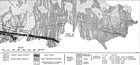
FIG. 14 Part of the South Coast of the Ardnamurchan Peninsula. (Based on Geological Survey)
These lavas invaded a forest, for in more than one instance there are trees preserved in the lavas or breccias. “An actual tree trunk was discovered by Macculloch embedded in lava along the coastal cliffs south-west of the wilderness …. The trunk is represented by a cast infilled with ‘white trap’ (i.e. bleached basalt) and charred wood, five feet across and forty feet in height. It stands erect, surrounded by a remarkable columnar basalt.”1 The horizontal element in the scenery of much of the island of Mull is perhaps best appreciated from a ship, but the views seawards from the high ground near Dervaig also emphasise it. The view across the Sound of Iona looking toward the north-western corner of the Ross of Mull, with Ardmeanach and Ben More also in sight, is an instructive one in the way it illustrates the effect of different types of rock on scenery. The foreground of Lewisian Gneiss, the pinkish granite east of the Sound, the glaciated granite knobs, the horizontal nature of the basalt country, and the great volcanic pile of Ben More are unforgettable.
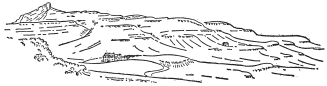
FIG. 15
—Eigg showing the Sgurr and the terraced appearance of the island. (After A. Harker)
Sills of igneous material, if on a big scale, may be sufficient to form islands by themselves. In the Shiant group, there are two main islands, Garbh Eilean and Eilean an Tighe, tied by a shingle beach (Fig. 16). The former is over 500 feet high and on its northern side is bounded by sheer cliffs. Farther to the east the lower part of the cliffs is scree-covered and partly overgrown. Eilean an Tighe, just over 400 feet high, is also bounded by high cliffs. Both islands are essentially formed of a single sill of dolerite, some 500 feet thick, and inclined at angles of 10°–15° to the south-west. Consequently the western sides of both islands have comparatively gentle slopes, whereas the scarp slopes to north and east give almost vertical cliffs, except that the great boulders fallen from them collect at their foot. The sill also shows columnar structure, both the diameter and length of the columns being far greater than in Staffa. The columns are nearly straight, but curve slightly near their summits on Eilean an Tighe and on parts of the north face of Garbh Eilean, where some individual columns are 350 feet high, and have an average diameter of five feet. Whilst the columns are generally hexagonal, other patterns also occur.
Apart from the columnar jointing there is also another set of major joints running approximately north-north-east and south-south-west. On the cliff face on the north of Garbh Eilean near Glaic na Crotha, they have a marked effect, and the rock is broken into great and roughly parallel slabs, instead of into individual columns. On the south-west of the same island, where the coast is very steep, there is a similar phenomenon, and there, too, the columns overhang and fall into the water. Hence, some of the big joints have opened out and great fissures running in a northerly direction into the rock have been made by wave action working along lines of weakness formed along these major joints.
The adjacent island, Eilean Mhuire, is also cliff-girt, but is made up of nearly horizontal sills of dolerite separated by three beds of Jurassic strata. To the west of Garbh Eilean is a chain of small islands, called collectively Galtachean. They too are composed of dolerite, probably the remnant of a great single sill. All show well marked columnar structure. The inclination is very variable and the curvature of the columns often conspicuous. All the Galtachean have steep and rocky north-facing cliffs. The Fladda isles are also doleritic and show good columnar structure, caves, and other similar features. They are interesting, but not as spectacular as the Shiants.1
The little Isle of May in the Firth of Forth is another example of a single sill, in this case inclined to the north-east at a low angle. Here again the dip slope is gentle, and there is a steep slope to the south and west. There are many east-west faults cutting through the island, which, while they have caused little if any displacement, have nevertheless broken the dolerite so that the sea has been able to eat out gullies or geos along these lines of weakness. In the northern, and flatter, part of the island, the geos allow water at high tide to pass through the island.
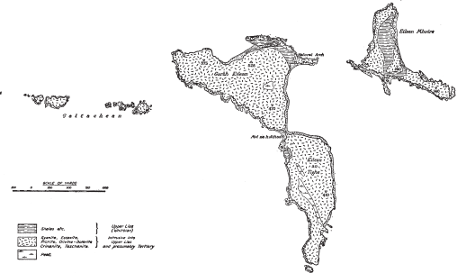
FIG. 16—The Shiant Islands. (After F. Walker)
Another interesting feature is that although columnar jointing is often conspicuous in the western cliffs, it is effectively masked by jointing parallel to the cooling surface of the sill. Other major joints have also played a great part in cliff structure; they have led to the development of rock stacks and arches, the best examples being the Mill Dorr just north of Pilgrim’s Haven. On the gentle north-east side the dip and jointing are approximately parallel, and a group of skerries, called the Middens, has been produced a short distance offshore.
The cliffs reach a maximum height of 150 feet on the western side, and there are clear traces of raised beaches at 50 feet, and probably at 25 feet and 100 feet. Marine erosion has therefore made great use of the lines of weakness in the sill to give it its present features. It is not, however, clear how far the features are the product of present-day conditions of sea level.
There are many other examples of sills and lava flows that might be given from the western isles of Scotland. As another instance, however, consider the Great Whin Sill which provides such striking and characteristic features on the Northumberland coast. There are various outcrops on the coast, but the main one is that between Dunstanburgh Castle and Cullernose Point. At both these headlands good columnar structure is seen in the high cliffs facing north at Dunstanburgh and south at Cullernose. Between the two places the sill has a seaward inclination, and between tide marks the water is washing a clean surface, much broken by rough and irregular jointing, although pentagonal outlines are commonest. There are also enlarged joints, crush-lines, and small faults, nearly all of which trend east or north-east. There is a major break at Craster harbour, Hole o’ the Dyke, which appears to be due to a crush belt. In it is a mass of Whin showing joints running in all directions. Since the inclination is seaward, the ground rises inland, and a few hundred yards from the shore the Whin forms a fine escarpment facing westwards. Thus, most of the shore exposure corresponds to the gentle slopes we have met in the Shiant Islands and in the Isle of May. (See Pl. XXI).
In strong contrast to the dark cliffs of basalt and dolerite are the pink and grey cliffs of granite in the Land’s End Peninsula, the Isles of Scilly, Peterhead, and a few other places. Granite varies a good deal within itself, but it is characteristic of it that it often weathers into great cuboidal masses. The form of cliffs will, however, depend a great deal upon the nature and inclination of the joints and of other lines of weakness. Often granite cliffs form fine castellated masses, since both marine and subaerial erosion work quicker along joints and other planes of weakness, thus causing the solid rock in between to stand salient as buttresses and walls. This is excellently developed between Land’s End and Penberth, where the cliffs are steep and subject to the full onslaught of the Atlantic. There are many coves, and the cliff top, over which salt spray is blown, is a fine open heather-covered moorland reaching as far as St. Levan. Nearer Lamorna, the cliffs have a gentler slope and are less spectacular; much the same is true near Land’s End.

