Полная версия:
The Sea Coast
Once a beach has formed either alongside a cliff or as an offshore bar, or in any other locality where there is room for it to develop, it will probably extend one way or the other as a result of beach-drifting. This process is important, not only physiographically, but economically since it largely accounts for the sanding or silting up of many harbours. The general effects are seen in many places, but in few are they better exemplified than in Sussex and Suffolk, The Arun, Adur, Ouse, and Cuckmere, are all deflected eastward by shingle ridges. In Suffolk, Orford Ness, and the smaller spits at the mouths of the Deben and Orwell are of the same nature. Spits grow rather like an embankment or tip heap. Beach-drifting gradually sweeps material along them and, at their ends, adds to the dump. Since the process is fairly continuous, it follows that the accumulated deposits may be conspicuous. On the other hand a spit growing out in this way across a river mouth, or across a bay or other re-entrant in the coast is easily attacked by the waves, especially those that approach it from a direction contrary to that of its growth. For this reason the free end of the growing spit is often turned or bent inwards, and in rather more severe weather large parts of it may be completely cut off.
Changes of this kind are common, but we do not know the precise causes. We know that in a certain storm such and such a spit was shortened, and we may make a shrewd guess as to what may have happened. But precisely what happened and why is quite another matter. Similarly, it is a well-known fact that many sand and shingle beaches, but especially shingle ones, are not merely a simple line of stones, but have running back from them branch ridges called laterals, or recurved ends. Figs. 25 and 26, show this. Each lateral ridge was at one time the distal or free end of the growing spit. Later, for some reason or other, conditions caused the main beach to lengthen again, and to continue to do so until another lateral was formed. Figures 25 and 26 show that the laterals often meet the main ridge at high angles, even at right angles. The newer laterals, especially those we may see forming over a period of years, may bend gently round. Hence, something has happened to bring about the abrupt junction of the older laterals with the main ridge. The main beach has been over-rolled on to them as is indicated in Fig. 24. A direct proof of this inrolling can sometimes be found if marsh deposits are exposed on the foreshore. These deposits can often be shown to have originated inside the spit, which because of the occasional overtopping by big waves has been rolled landwards. A misleading impression of stability is given if the main ridge is now dune covered.
In another chapter some of the coastal districts in which these lateral ridges are well developed are analysed. In this, it is emphasised that each such ridge was built by wave action, and was therefore at one time the outer ridge, and it follows that if one ridge lies in front of, or cuts across another, it is the newer one. Thus by carefully mapping the ridges, and noting their relationships one with another, the evolution of the whole structure of a shingle foreland may be investigated. Difficulties occur, especially in places where the ridges are in groups, but the groups themselves separated from one another. It is, for example, far from clear just how the several groups which are truncated by the present beach ridge on the southward facing part of Dungeness are related to one another and to the formation of the whole foreland. Reconstructions that have been made are quite possible, even probable, but they remain hypothetical (see here).
It may also be remarked that Benacre Ness has altered greatly in form since the current Ordnance maps were published. The Ness point is now considerably farther north, and the southern end near Benacre Broad has suffered severe erosion. To balance this, there has been accumulation at or near the sluice.
1 At the northern part of Kessingland and again at the southern end of Aldeburgh, new groynes have recently been built. In both cases they have been successful in collecting some beach, and it is interesting to note that at both places, perhaps more markedly at Kessingland, a reversal of beach drift seems to have taken place. As a rule the beach is piled up on the south side of the groynes, pointing to a northerly movement. This seems to be quite local, but no ready and adequate explanation is forthcoming. It may also be remarked that Benacre Ness has altered greatly in form since the current Ordnance maps were published. The Ness point is now considerably farther north, and the southern end near Benacre Broad has suffered severe erosion. To balance this, there has been accumulation at or near the sluice.
2 It is well known that large cobbles on which seaweeds grow can be carried long distances in this way. The remark in the text applies to bare stones and cobbles.
1 Approximately the relation between the movement of the particles and the depth is: “If L is the length of the wave, the movement of the particles from the surface downwards decreases one half for each 1/9 L of depth; i.e., at a depth of 1/9 L the movement is 1/2 that at the surface; at 2/9 L it is 1/4 the movement at the surface, etc.” (R. S. Patton and H. A. Marmer, The Waves of the Sea, in Physics of the Earth; V, Oceanography, Bull. Nat. Res. Council, Washington, 1932.)
1 J. S. Owens and G. O. Case, Coast Erosion and Foreshore Protection, Ch. iii, 1908.
2 Geogr. Journ. 78, 1931, 131.
1 W. V. Lewis, Proc. Geol. Assoc., 49, 1938, 107.
1 See D. Haldane, Trans. Edin. Geol. Soc. 13, 1931–38, 442. The nullipore is a robust form of Lithothamnium calcareum, Aresch, and at low tide can be seen growing on the spit connecting Lampay Island with the shore. Nullipore sands also occur at Loch Bracadale, Morar, Arran, Lower Loch Fyne, South Bute, and Cumbrae.
CHAPTER 3
EROSION AND ACCRETION:
EVIDENCE OF COASTAL CHANGES

IN OTHER parts of this book there are references to recent changes in the coast, to erosion and deposition. In this chapter an attempt is made to try to bring together various lines of thought to show the close interlocking between physiographical studies of the coast, archaeology, and history.
It is logical to work from early times up to the present, but that approach may be dangerous, since accounts of early changes are often based on too few facts but on considerable imagination. Changes today are taking place mainly by erosion or by deposition; the slow vertical movement of the land surface suspected in south-eastern England may be very important in the long run, but need not be discussed at the moment (see, however, here).
Consider first the question of the rate of erosion of cliffs. Erosion to some extent is taking place in many parts of our coasts, but it is most marked in softer rocks or where for some reason the structure of the cliffs favours it. (See Chapter 5.) The most spectacular example is the Holderness coast of Yorkshire. Recent analysis suggests there are three main factors associated with this erosion.1 From Bridlington as far as Barmston the cliff was not suffering in 1947, but it was thought that a good deal of erosion was taking place on the sea floor for one or two miles outwards from the beach. The water is heavily charged with clay, and the staining thus produced extends in long tongues to the south-east. On the other hand between 1840 and 1890 erosion along this line of cliffs was severe. From Barmston to Spurn Head erosion is serious, and averages two to three yards a year, and in places a rate of five yards over a period of years has been reached. Most of the pill-boxes erected on the cliffs during the 1939–1945 war are now half submerged in the beach sands. Houses have been wrecked by the collapse of the promenade at Withernsea, and at Skipsea a farm building, which in 1945 was slightly damaged at one end by cliff falls, was in 1947 derelict, half of its 45 feet of length having disappeared.
In Holderness, as often elsewhere, much of the erosion is attributed to the drainage of land water. Springs from interbedded gravels and water from land drains cut deep gullies in the cliffs. Other reasons, apart from the direct attack of the waves, include the loosely compacted nature of much of the boulder clay in the cliffs, the action of frost in cracks, the low equilibrium angle (c. 5°) of wet boulder clay and the fact that the waves sometimes build storm beaches of fine shingle on the beach. Behind these ridges water may be impounded and seems to have a softening effect on the base of the cliff.
This is but the modern continuation of a long process. In 1895 the British Association for the Advancement of Science appointed a committee to inquire into the rate of coast erosion, which some years later produced the following figures for Holderness. The period covered was 1852–1897, or 37 years, and the figures refer to sheets of the six-inch Ordnance Survey.
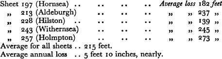
Sheppard examined earlier records of the district and has shown that erosion has gone on continuously since at least Roman times. Records of the loss of land in four townships between 1086 and 1800 have been analysed. “The coast of Holderness, from Barmston to Kilnsea, is 34½ miles long. Assuming the land has been carried away equally throughout this distance, there has been a strip of land 1089 yards wide washed away, at the average rate of 7 feet 1 inch per annum (i.e. A.D. 1086 to A.D. 1800). If the denudation since Roman times has been at the same rate, 53,318 acres, or about 83 square miles, have been lost. This is equal to a strip of land 2½ miles in width for the whole of the distance.”1 In 1885 Reid estimated the average annual loss at 2¼ yards. The rate, however, varies from time to time and also in place. Groynes put out to protect Withernsea, for example, have led to increased loss south of that town.
Erosion is severe along several parts of the coasts of Norfolk and Suffolk, and even in what are regarded as fairly hard cliffs it is often rapid. At Hunstanton a pill-box built on the cliff top during the 1939–45 war was partly undercut in 1948.2 The sea eats into the comparatively soft Lower Greensand and so causes falls of the chalk above. It is estimated that the average rate of erosion between Hunstanton and Heacham is of the order of a foot a year.3 This is interesting, since the mouth of the Wash might be regarded as a sheltered area. Between Sheringham and Yarmouth erosion is locally serious, and those familiar with the coast road near Bacton and the neighbouring villages will know that it has had to be relaid farther inland. At Overstrand the sea has cut well into the cliff and has nearly undermined a large hotel and some neighbouring houses (all now pulled down). (The storm of 31 Jan., 1953, did much damage at Bacton.)
It is impossible and also unnecessary to comment on all places where erosion is serious, but a few examples may be given. The figures below for the neighbourhood of Lowestoft4 are revealing:
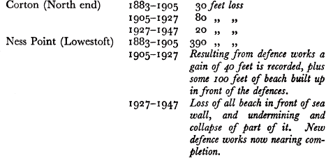
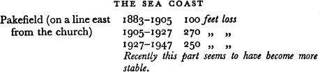
Lowestoft is in an exposed position, and is the most easterly point of this country. As explained here, the coastal drift is from the north, and much is held at Yarmouth, Of recent years also changes in the form of the sand banks off shore and of the set of the currents are held to be contributory causes of the severe erosion at Lowestoft.
The Isle of Sheppey affords another instance of loss. Between Scrapsgate and the jetty, south-east of Warden Point, along a total length of five and a half miles, the loss of land between 1865 and 1906 was 103 acres, or taking an average for the whole length of the line, an annual loss of 3.8 feet. At Warden Point itself the loss reached 9·7 feet a year on an average. The subsequent evolution of the part near Warden Point is shown in Figure 5.1
Erosion takes place in harder rocks and cliffs, but as a rule very slowly. Records are scarce, and usually only occasional big slips, if the structure is favourable, or some spectacular change, are remembered. Chalk is a rock of intermediate hardness. Near Birling Gap, west of Beachy Head, no record is kept, but there is an estimated loss of two feet a year. This, however, is very erratic and irregular in its incidence. At Seaford there is said to be some erosion of the Chalk cliffs, but what changes occur appear to be mainly the result of frost action.
All round the coasts of Great Britain other examples could be found, and doubtless the reader will know some of them. Generalisations should be avoided, or at least used with discretion. The amount of erosion even in soft cliffs is often exaggerated, and the figures given show how it can vary with time. Local exposures of boulder clay such as those south of Aberystwyth, or those west of Criccieth, retreat comparatively quickly. These are mentioned because Cardigan Bay may all too readily be dismissed as a coast wholly formed of hard rocks. The damage in 1938 at Aberystwyth itself is worth bearing in mind.
Erosion is not a serious problem in Scotland. There are some places which are affected, but seldom to the extent of those in England.
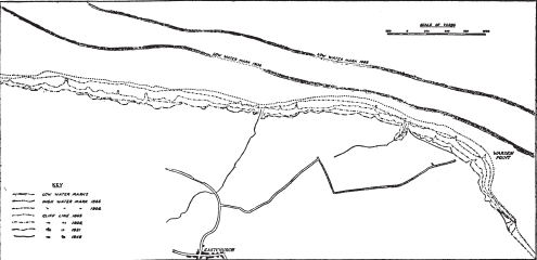
FIG. 5 Erotion in the Isle of Sheppey
(After F. W. S. Stanton and Ministry of Town and Country Planning)
The Royal Commission in 1911 reported on several cases including, for instance, the Wigtownshire coast of Luce Bay between Sandhead and Drummore where local erosion has cut into the main road. Along the coast of Ayrshire and also in Arran the raised beaches (see here) which closely follow the coast and carry the main road are subject to some erosion. At Golspie, in Sutherlandshire, the erosion was estimated at two yards a year, a very high rate for any part of the Scottish coasts. It is still active at this place. There is also local erosion at several places along the coasts of Moray and Banff, including the Bay of Gamrie in which the picturesquely placed villages of Crovie and Gardenstown are situated. There are several other places along the east coast where erosion occurs, but in nearly all the Scottish examples the reason given to the Royal Commission was the same, namely, the local removal of shingle. It is instructive to quote from their Report: “This erosion (on the East Sands) has been going on for a long time, and within the last ten years the coastline appears to have receded about 20 or 30 feet. The erosion principally affects the property belonging to the University of St. Andrews, and it appears to have been accelerated by the removal of materials under the authority of the Corporation—who claim the foreshore—from the beach. The representative of the Corporation who gave evidence admitted that the removal greatly assisted the erosion.” Removal of beach material may be important. The force of the sea expends itself on the beach, and if sand and shingle are indiscriminately taken away, especially from places where natural replenishment is slow or absent, erosion is bound to occur.
Conditions at Stonehaven afford an interesting example of local erosion. In recent years the town beaches have suffered a continuous loss of material. The littoral drift carries away material to the south, but the supplies from the north have not kept pace. Every now and again considerable quantities of material are deposited on the Stonehaven beaches, and across the mouth of the River Cowie. This in turn may cause the river to change its course near high-water mark, and also, since its velocity is thereby reduced, makes it unable to carry as much suspended material as usual to the sea. Thus a gradual rise in the level of its bed can take place. If then there follows a heavy flood, the impounded water of the Cowie breaks through the shingle, and this occasionally leads to severe scouring of the bed and banks of the river. A sudden lowering of the river bed by as much as four feet has been known to occur in a few hours following a single rain storm.1
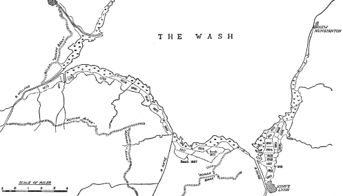
FIG. 6
Reclamations in the Wash. (After O. Borer)
In Chapter 6 the way in which accretion occurs on Salt Marshes, and the speed of the process, are considered. Here we must turn to the wider question of accretion in general and the inning or embanking of slob lands. Accretion is most likely to occur in sheltered inlets, estuaries, or behind shingle bars. To study the process in action the coasts of the Wash should be visited. Figure 6 shows the position and extent of many recent reclamations. Since Roman times it is estimated that 8000 acres have been gained on the Norfolk side of the Wash, and in South Holland 37,000 acres. In early days banks were often built rather prematurely, but now it is realised that the longer the period of natural accretion goes on, the better the land reclaimed. In the Wash warp begins to be deposited at about +5 feet O.D.; neap tides rise to +8 feet, and at this level Salicornia spp. appears. At about +10 feet it is replaced by grasses. Nowadays, the foreshore outside a new bank becomes grass marsh in approximately ten years, but to get the best results it is left in a natural condition for another twenty or twenty-five years. The salt marshes in the Wash carry a vegetation typical of east coast estuaries—Salicornia spp., Suaeda maritima, and Aster tripolium give place to Puccinellia maritima and Obione portulacoides along the creeks. Spartina townsendii has been introduced. In 1925 there was a little at Wolferton and on the banks of The Cut; today there are extensive areas between Wolferton and North Wootton. Since Puccinellia is much grazed, there is no further development until the marsh is embanked. Limonium and Armeria are absent, and the only other species worth noting is Cochlearia officinalis. An interesting fact is the speed at which the ordinary halophytes2 disappear once a marsh has been reclaimed; even within a year they have been replaced by docks, nettles, thistles, buttercups, and daisies. Since 1932 much of the reclaimed land has been ploughed, and it yields good crops. The saline origin of the ground still, however, shows in the drainage ditches; in one example in a ditch of a marsh reclaimed in 1904, Puccinellia maritima remained the dominant plant in 1945. A pond in a reclamation made in 1865 was 80 years later still fringed by Scirpus maritimus, Puccinellia maritima, Aster tripolium and Spergularia salina. If water drains from the upland, fresh water aquatics only come in very slowly.1
Here and elsewhere accretion on the natural marshes is encouraged by cutting ditches, or grips, running up and down the marsh. A fall of about two feet a mile is given to them, and the excavated material is usually dumped on the seaward side. This helps to produce calm water and foster deposition. If any erosion of the excavated material takes place it is spread over the grassland. The ditches are found to help the ebbing tide and to aid the consolidation of the deposited material before the next tide covers it. They are about 60 or 70 feet apart, and cut when the marshes reach about +10 feet O.D.
Apart from local variations in the nature of the marshes, exposure, and other factors, the process of reclamation in the Wash is virtually the same as that in other parts of the country. If a rapid survey is made of our coast, it will be noticed that great changes have taken place in Romney Marsh and around the Parrett mouth in Somerset, and in the reclamation of the extensive Fenlands of East Anglia and Yorkshire. More modern changes are rapidly taking place in Southampton Water and Poole Harbour and other places on the south coast. This is mainly the result of the introduction of Spartina townsendii, a plant which first appeared in 1870, and since then has spread very rapidly, and has been planted on many other parts of the coast to help reclamation. “The stout stem bears stiff erect leaves: from the bases of the stems stolons radiate in all directions, binding the soft mud; and feeding roots, mostly horizontal in direction, ramify through the surface layers of the mud, while stouter anchoring roots extend vertically downwards. The leaves offer broad surfaces to the silt-bearing tidal water, and their points catch and hold fragments of seaweed and other flotsam. The thick forest of stems and leaves breaks up the tidal eddies, thus preventing the removal of mud which has once settled on the marsh …. No other species of salt-marsh plant, in north-western Europe at least, has anything like so rapid and so great an influence in gaining land from the sea.”2
Another district in which there has been a good deal of reclamation is Morecambe Bay. Although local conditions favour the process, the results are not of any great value, since it is sand rather than silt which is deposited. The sand is derived mainly from Triassic rocks and boulder clay, and is chiefly quartzose and well rounded. Since, however, it is free from silt it is more or less useless. This fact was strongly emphasised by the Royal Commission (1911), and in their report they also noted that of one thousand acres reclaimed near Morecambe, nearly half had been abandoned.
In the Solway and other firths of Scotland, considerable reclamations have been carried out. There is no need to detail instances, since it is clear that as far as natural and sheltered conditions are concerned, localities in the firths are obviously suitable for this purpose, partly as a result of seaborne silt, partly of river borne material. Around Dingwall, for example, the Conon and Peffery rivers deposit a great deal of sediment. On the other hand, diversity of interests must be considered. It may seem an obvious advantage to take in more land, but on the Clyde some reclaimed lands had to be removed, since they were detrimental to the more important navigation interests.1
A word is desirable about the lateral spread of natural marsh. If comparisons are made between two separate editions of the six-inch Ordnance Survey of selected areas, the spread can be measured. Since the surveyors were probably not ecologists it is not always clear what boundary they took for the vegetation. In certain cases known to the writer, however, reasonable measurements can be made in this way. Nowadays the quickest method is to compare two air photographs of the same place taken a few years apart. Anchor marsh, a small enclosed marsh on Scolt Head Island, was almost bare of plants in 1920, but in 1939 it was thickly carpeted and a good deal of mud had also accumulated. Holme marsh, near the entrance to the Wash, seems to have developed from a sand flat enclosed in part by a shingle ridge to its present fairly advanced state since 1858,
Loss and gain of land are going on constantly. Erosion is nearly always more spectacular, especially if houses or other buildings are caused to fall. Yet it is the slow unnoticed process of accretion in estuaries and other places that is the more valuable. The Royal Commission in 1911 found that in total area, accretion far exceeded loss. No other comprehensive measurements have been made since then, but we can assume without any doubt that the statement is still true.
If, however, we go back in time, even only for a century, we are soon in difficulties. Much of our present fairly detailed knowledge depends mainly on present-day observations and measurements—all too few—specifically designed to tell us of loss and gain. The large scale Ordnance Survey maps are nearly always our first reliable means of measurement, and they date back only to the early decades of the nineteenth century. Earlier maps are seldom reliable; sometimes particular surveys are very helpful, but it is rare to find anything before the eighteenth century on which accurate distances can be obtained. This does not mean that early maps are useless; far from it. They must, however, be used with great caution and their information, where possible, checked in other ways. Erosion and accretion are both irregular in their rates of action, and for this reason alone averages over a long period must not be taken as holding good for other periods of similar length. All kinds of factors may intervene; a sand bank may be thrown up offshore or in front of a cliff and so hinder direct erosion; wearing down of the shore platform may allow bigger waves to break near the cliff foot and so increase the rate of loss; if the sea is cutting into land sloping upwards to the interior the rate will gradually decrease, since the waves have to remove an increasing amount of waste per unit of advance; the exact converse of this may lead to quicker erosion. These and many other local factors must be taken into very careful consideration if we delve back into the past and try to estimate loss or gain in early times.

