Полная версия:
Russia the formation of the state in the 9th century Veneds and the severjans (northerners), part of the Huns, which became the basis of a new community
The very scale of development of Abashevsk metallurgy is also determined by the finds of a series of Abashevsky metal, considered in the literature under the concept of “treasure”, which geographically gravitate towards deposits in the Urals and in the Trans-Urals (Krasnoyarsk, Verkhne-Kizylsky, near Dolgaya Gora, etc.). Their finds do not cross over to the right bank of the Volga. Moreover, some of the “treasures” are hardly left directly by the Abashevo population. Some of them (Galichsky, Korshunovsky, Morozovsky) may testify not so much to the direct settlement of the Abashevites in the forest regions of the Volga region, as to the spread of the Abashevsky metal to more northern territories. This population first erected large in area two-chamber or multi-chamber, with a gable roof, slightly deepened into the mainland dwellings, and then large in area, also slightly deepened into the mainland, but already single-chamber buildings with an adjoining vestibule part.
The Abashevo population is characterized by a burial ritual under the kurgan with the construction of flattened embankments. The presence of an interval between the time of the burial and the erection of the embankment is noted. A feature of the burial rite of this population was the erection of circular (less often rectangular) extra-grave structures, limiting a significant area around one or several graves. The presence of independent rectangular pillar structures around individual burials is sometimes noted. The burial rite of the Abashev population is characterized by a cult of fire that manifests itself to varying degrees (burning of ground structures, pouring burning coal into the grave, etc.) and animal sacrifices (the position of parts or skins with head and legs). The grave pits are most often elongated rectangular, sometimes they have a wooden or stone design. The dead were laid on their backs with their legs extended or raised. The eastern and southeastern orientation of the dead is more common. The presence of dismembered, partial, i.e. repeated burials was noted. Finally, the complete absence of skeletons in a number of burial pits testifies to cenotaphs, which confirms the presence of some complex, so far incomprehensible burial traditions among the Abashevs, which also brings them closer to the Hellenic tradition. Single burials are common. But in the outlying areas, especially in the zones of contacts with foreign-cultural tribes, collective burials of the type of mass graves are not uncommon: the Pepkinsky and Staro-Ardatovsky kurgans in the Middle Volga region, the I Yukalekulevsky kurgan in Bashkiria. The most characteristic of the kurgans are stone extra-grave structures that are not characteristic of other Abashev cultures. Only here the stone was widely used in the design of grave pits. In a number of cases, powerful bonfires are noted that burned over the grave pits after the burial. More often than in other territories, the presence of partial and repeated burials is recorded. The dead were laid on their backs stretched out or with their legs raised. There is no stability in the orientation of the dead.
Among the forms of ceramics, most of all bell-shaped bowls and fewer bell-shaped pots. The bell-shaped vessels here often have a significantly lower rim height. Images of a meander and a swastika appear on the vessels. The dishes are also blackened or dairy, traditional for Indo-Europeans.
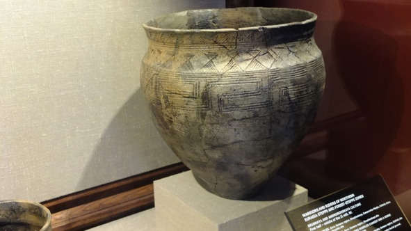
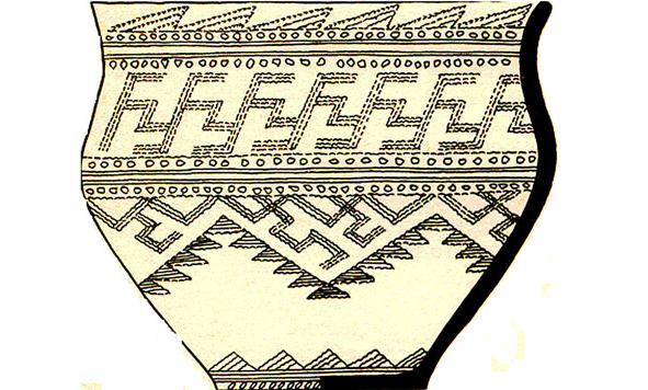
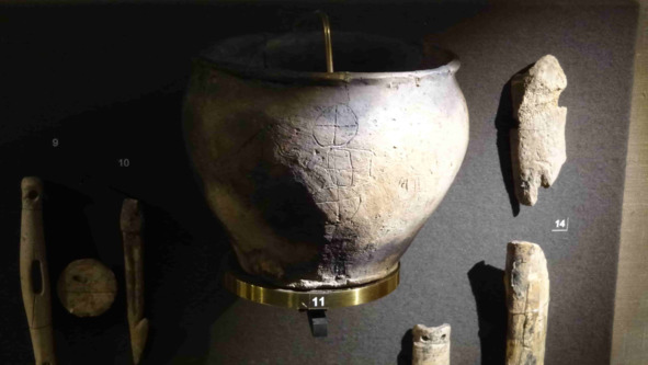
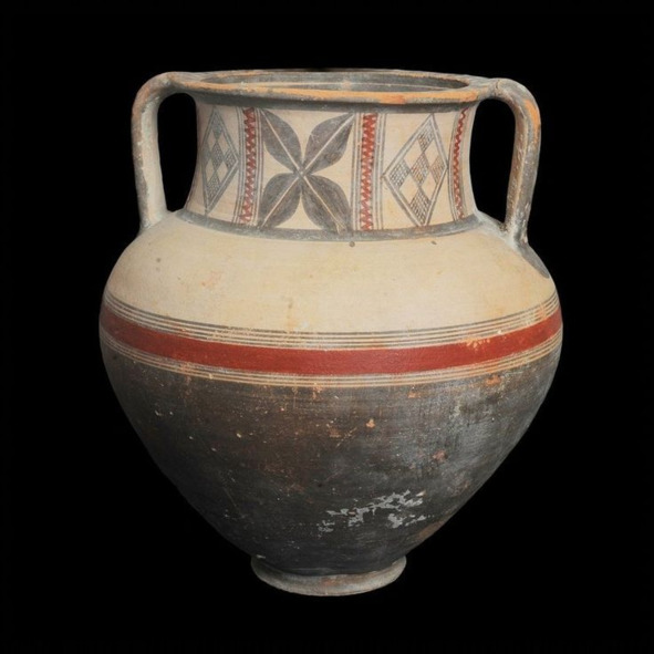
A vessel from the State Historical Museum, Abashevskaya culture. Meander.
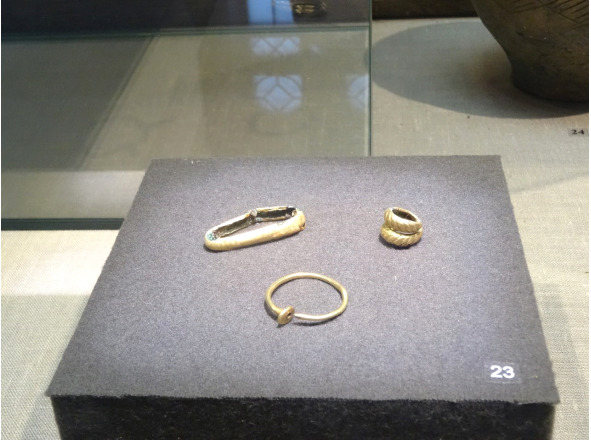
Temporal lobular rings
Differences are manifested even in small sharp-ribbed vessels – the presence of a direct fall in the neck region from the inside is especially indicative. In the decoration of vessels, meander and lobed patterns are much more often noted, the tradition of decorating their lower part with a vertical herringbone, etc. In the Ural territory, bracelets rounded in cross section with open blunt ends, metal onlays, and plate plaques are widespread. The bracelets are spiral, and also from the time of the catacomb culture, temporal lobed rings have been used.
Only here are multiturn small grooved pendants and metal beads known. The set of metal tools and weapons is significant. The outlined solution to the question of the origin and further fate of the Abashev population also determines the approach to clarifying the ethnos of this population. The denial of the genetic relationship with the Abashevs of the previous cultures of the forest Volga region, as well as the absence of direct inheritance of the Abashevo traits by the Finno-Ugric cultures of the early Iron Age of the Volga region, is a serious argument in favor of the denial of the Finno-Ugric ethnos of the Abashevites. At the same time, the definition of their ethnos as Indo-Iranian is becoming more and more obvious (for the first time such a point of view was expressed by A. Kh. Khalikov). This interpretation of the ethnos of the Abashevs receives additional argumentation in connection with new arguments in favor of the fact that the Abashevs, by their historical roots, development and further fate, are connected with the world of the massifs of the population of the ancient Pit, Timber and Alakul cultural and historical communities, which are now more and more definitely considered in direct connection with the problem of the early history of the Indo-Europeans, and then their group of Indo-Iranian offshoots.
Andronovo culture
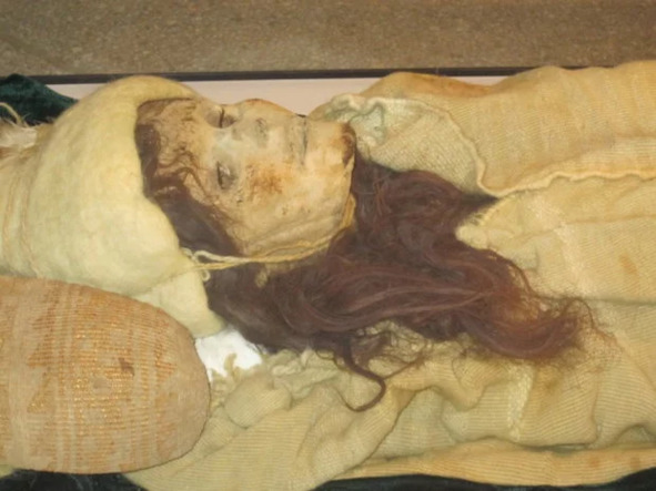
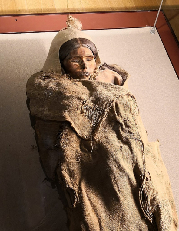
Andronovo culture (cultural and historical community) is the general name for a group of closely related archaeological cultures of the Bronze Age, which covered in the 17th-9th centuries BC. e. Kazakhstan, Western Siberia, the western part of Central Asia, the Southern Urals, as well as Northwestern China, the Gansu province (article by A. Bekhter, S. Khavrin V. Steppe bronzes from the Gansu province and Xinjiang Uygur Autonomous Region of China and east sync line). The people of this culture were called, already Huns or Hans, from a totem or farn, a sacred animal, a swan. This is where the name of Ganxi Province comes from. Here it is also necessary to remember the discovery of Tarim mummies belonging to the Andronovo culture, according to the ceramics monuments. A Swedish archaeologist excavated in 1939. there are almost a dozen mummies and about 200 artifacts. Bergman left a detailed description of his findings in a work entitled “Archaeological Researches in Sinkiang Especially the Lop-nor Region” (Archaeological Research in Xinjiang, especially in the Lop-nor Region). By the early 1990s, more than 1,000 Nordic mummies had been unearthed in China’s Wapu province, but in 1998, the Chinese government banned further excavations, apparently out of concern that even more startling evidence would come to light. the presence of Caucasians in ancient China. So researchers in 1980, deep under the “sea of death”, found the mummy of a beautiful girl, nicknamed the sleeping beauty Lulan. According to scientists, the remains are 3800 years old. One of the famous Tocharian mummies, known as “the beauty of Loulan” and reconstruction. It belongs to a young Caucasian woman (180 cm tall and locks of light brown hair) and was found in 1980 in the vicinity of Loulan. Approximate age 3800 years. And what is important, the extremely high growth of the deceased – men 200cm tall, women 180cm.
In China, obviously, the people of the Andronovo culture founded the Shang-Yin state, here the parallels in the manufacture of bronze cauldrons of the Shang-yin and later Sarmatians and Huns are extremely interesting. The Andronovites-Huns-Hans, gave the name to China and the Chinese. The self-name of the Chinese is hànzú. (Gansu). Even in the hairstyles of the Chinese-ban-fa there was a trace of the Andronov-Gans.
One of the deities of China is still called Gong-Gong, the Deity of water. The Chinese imagined him with a snake-like body and a human head. Let us recall the giants-giants of Greece, half-snakes, Erichthonia of Athens, also a half-snake. At the crown of Gong-gong there is a thick head of red hair, that is, the traditional Huns’ hairstyle is a shaved head, and the hair is only on the back of the head, and red. In myths, the main enemy of Gong-gong is Chzhuzhong, and even here the legend of the confrontation between the Gongs (Gans) and the Chou (the Chinese proper) remains.
Another interesting find of the Seima-Turbino period is a scraper knife, whose handle is parallel to the blade, that is, the blade is inserted with its lateral edge into the bone handle. The knife was found at the Weijiatai monument, Linxia county, Gansu province (Tian Yuzhan, 1983, p. 76, Debaine-Francfort 1995, fig. 49.8) The name of the whole culture comes from the village of Andronovo near the city of Achinsk, where in August 1914 A. Ya. Tugarinov discovered the first burials.
The formation and formation of the Andronov cultural and historical community took place over several centuries, starting from the turn of the III – II millennium BC. e. The Andronovo culture as a single community took shape on the territory of Kazakhstan by the 16th – 15th centuries. BC.
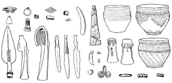
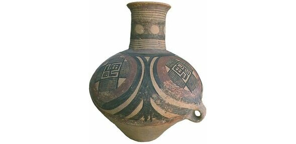
Andronovo culture ceramics
Within this unity, the Alakul and Fedorov cultures are formed. Alakulskaya spread in Central and Western Kazakhstan, and Fedorovskaya – in the territory of Eastern Kazakhstan. In Central Kazakhstan and Semirechye, signs of both cultures are found simultaneously. Subsequently, the tribes migrated from the territory of Kazakhstan to the east and south, up to Iran. M.P. Gryaznov singled out the materials of the burial grounds he studied in the basin of the river. Ural is the western version of the Andronov culture, which dates back to the XIV – XI centuries. BC e. The Andronovo culture was identified by the Soviet archaeologist S.A. Teploukhov in 1927. Research was also carried out by archaeologist K.V. Salnikov, who in 1948 proposed the first classification of the Andronov culture monuments. He identified three chronological stages: Fedorov, Alakul and Zamaraevsky.
Seima-Turbino culture, State Historical Museum
Currently, the Andronovo culture includes at least four related cultures:
Sintashta-Petrovka-Arkaim (South Urals, northern Kazakhstan, 2200—1600 BC,
– This is the fortification of Sintashta in the Chelyabinsk region, dating back to 1800 BC. e.,
– The settlement of Arkaim, also in the Chelyabinsk region, dating back to 1700 BC e.;
– Alakul (2100—1400 BC), in the area between the Amu Darya and Syr Darya rivers, Kyzyl Kum desert;
– Alekseevka (1300—1100 BC) in eastern Kazakhstan, the influence of Namazga-Tepe VI in Turkmenistan
– Ingalskaya valley in the south of the Tyumen region, in which the monuments of the Alakul, Fedorov and Sargat cultures successively replace each other
– Fyodorovo (1500—1300 BC) in Southern Siberia (for the first time there is cremation and the cult of fire);
– Beshkent region – Vakhsh (Tajikistan), 1000—800 BC e. The spread of the Andronov culture was uneven. In the west, it reached the region of the Urals and the Volga, where it came into contact with the log culture. In the east, the Andronovo culture spread to the Minusinsk depression, partially including the territory of the early Afanasyev culture. In the south, individual material monuments were found in the region of the mountain systems of the Kopetdag (Turkmenistan), Pamir (Tajikistan) and Tien Shan (Kyrgyzstan), in the area of settlement of Dravid-speaking tribes. Considering the problems of the history of the Andronovo cultural unity of metal products, N.A. Avanesova proposed the following periodization scheme: 1) pre-Alakul stage (XVII – XVI centuries BC); 2) the Andronovo culture (XVI – XII centuries BC);
– alakul stage (XV – XIV centuries BC);
– Kozhumberdinsky stage (XIV century BC);
– Fyodorov stage (XIV – XIII centuries BC);
– Zamaraevo-Begazin culture (XII – IX centuries BC) (1979, p. 20—21).
In the late 70s. OH. Margulan, without changing the sequence of genetic succession in the development of the tribes of Central Kazakhstan, proposed a new chronological framework for the stages, lengthening the Nurin stage (synchronous with Fedorov’s) from the end of the 3rd to the beginning of the 2nd millennium BC. e., almost 5 centuries; Atasu (synchronous with Alakul) until the 18th century. BC e., i.e. for 4 centuries, and the transition period to the Late Bronze to the XIII century. BC e., i.e. for one century, leaving the same dating of the Begazy-Dandybaev culture – X – VIII centuries. BC e.
The northern border of the distribution of the Andronovo culture coincides with the border of the taiga. In the Volga basin, there is a noticeable influence of the Srubna culture. Ceramics of the Fedorovo type were found in the Volgograd region. Questions of chronology and cultural affiliation of the Late Bronze Age monuments in Northern Kazakhstan were developed by S. Zdanovich, who singled out the Sargarin culture of the final stage of the Bronze Age, dating it to the X – VIII or even IX – VIII centuries. BC.
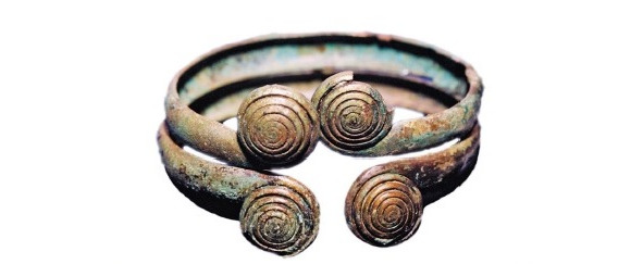
Sintashta, bracelet with volute.
In the Siberian steppes, a single economic and cultural type of shepherds-cattle breeders and farmers developed for all Andronovites, the Andronovites lived settled in long-term semi-dugouts. Their settlements were located in river valleys rich in pastures and fertile lands suitable for agriculture. The herd was dominated by cattle, sheep, horses. The Andronovites became the first riders in the Asian steppes. Livestock was kept in pastures for most of the year under the supervision of shepherds, and in winter in special pens. Cereals were cultivated on easy-to-cultivate floodplains. The soil was cultivated by hand with stone and bronze hoes. Hunting and fishing did not have much importance in economic life. They lived poorly, settled in large families in dugouts located quite far from each other; Many times they created settlements, but chaotic, spontaneous, not having a clear plan. Settlements in the form of 10 – 20 large dwellings.
Chariot on a blackened vessel, State Historical Museum
The dwellings were semi-dugouts and ground log huts. Some settlements (for example, settlements in the area of Petrovka and Bogolyubovo) were surrounded by ditches and ramparts, the land for which was taken from a fragment of the ditch. A wooden palisade was built on top of the ramparts. For passage inside, jumpers were left in the ditch, and a gate for the passage of chariots was arranged in the shaft.
Andronovtsy were the tribes of metallurgists. They possessed copper and tin mines and supplied the metal far to the west. Their foundry workers provided widespread production of tools (sickles, axes, Celts) and weapons (daggers, socketed points, spears with a leaf-shaped feather), including outside the Andronovo area. Deposits of copper ore were developed in Kazakhstan, as well as in the Altai Mountains. Burials were made in pits with stone embankments, sometimes surrounded by fences made of stone slabs. There are burials with wood cladding. The dead were laid in a crumpled position, the hands were laid in front of the face. The burials contain flint arrowheads, bronze tools and weapons, jewelry, and ceramics. The deceased was sometimes burned. Vessels with a flat bottom were decorated at the top and at the very bottom with imprints of a thin comb stamp or carved lines, often in the form of various geometric shapes – meanders, triangles, crosses, swastikas and meanders. Of the jewelry, again, spiral bracelets, temporal lobular rings, bracelets open with volute, drawing below.
Country of Cities
The country of cities is the name of the territory in the Southern Urals, within which ancient settlements of the Sintashta culture of the Middle Bronze Age (about 3—2 thousand years BC) were found. In historical science it is called the “Volga-Ural focus of cultural genesis.” The most famous settlement of the “country of cities” is Arkaim. The settlements were discovered in the 1960s – 1980s. One of the first (in 1968) a settlement was found near the Sintashta River (a tributary of the Tobol), due to which the found settlement itself received the name of the aforementioned South Ural river. Soon after the discovery of other settlements, archaeologists began to use the term “Sintashta culture”. Probably, judging by the finds, this culture is similar, if not identical to Andronovskaya and Abashevskaya. Most cities are round in plan-8.
– round (9 cities)
– oval (about 5)
– rectangular (about 11)
The houses gathered in a circle, and a kind of reinforcement was obtained from the end walls of the houses. The settlement was surrounded by a moat and a rampart. The outer rampart and wall were made of clay and stones, with a wooden frame. The houses and walls resembled FACHWERK houses in Germany, that is, they were frame.
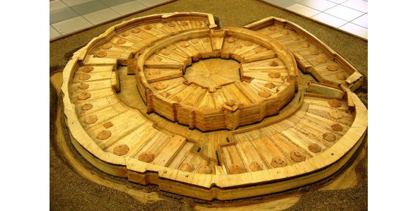
Arkaim
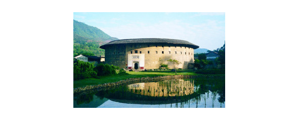
Tulou of China
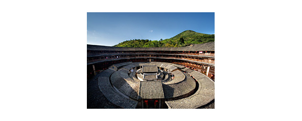
The settlements most of all resemble the so-called fortress houses of China, Tulou, pinyin Fújiàn Tǔlóu, literally “earthen [high] building”) – in Chinese architecture, a fortress-type residential complex common in the provinces of Fujian and Guangdong. There are square or round shapes. That is, the Tulou were also rectangular. The first tulou were built by representatives of the Hakka people, who, during the internecine wars, migrated from the north to the southern regions of China during the Tang Dynasty. Faced with hostile attitudes towards themselves from the local population, migrants were forced to build closed serf-type residential buildings..
Round-shaped tulou have a diameter of 50 – 90 meters, the thickness of the outer walls is from one to two and a half meters, they have narrow loopholes on the upper tiers and a minimum number of powerful entrance gates. Inside the fortress there were living quarters, a well, there were large supplies of food. In Tulou, 500—600 people can live, representing three or four branches of one clan. Tulou can accommodate 500—600 people, representing three or four branches of the same clan. For example, Chengqilou, a four-story round tulou in Gaotou Parish, Yongding County, was once home to more than 600 people from the Jiang clan. Now there are only slightly more than 60 residents (over 20 families) left, but, as they proudly note, if anyone wanted to live one day in each room of this building, it would take him almost a year.
“Tulou” can be translated as “earth castle” (tu = earth, low = building of several floors); however, both brick and stone were often used in construction (boulders in mountain districts, granite blocks in coastal areas). As a rule, a foundation was laid from stone (which made it difficult for enemies to dig during a siege) and the lower part of the wall was built, to a high enough level so that even in the highest floods, water would not erode the earthen part of the wall. The main material, however, in most cases was still a composite mixture of clay, sand and lime, laid and dried directly in the sun. As a rule, all residents of one tulou (except for wives who came to the clan from outside) had the same surname.
Probably, the culture of Northern China, the skill of building such fortress houses was brought to China by the Andronovites.
Deity of water Gong-Gong. The Chinese imagined him with a snake-like body and a human head. At the crown of Gong-gong there is a thick head of red hair, that is, the traditional Huns’ hairstyle is a shaved head, and the hair is only on the back of the head, and red. Shang-Yin ceramics has an undeniable resemblance to the Cretan one, and this is noticeable to everyone.
Shang-Yin Pottery
Cretan Pottery
The Shang-Yin state was created by the Europeans, the Andronovites, who were called Gans, from this ethnonym the name of the Gansi province originated. The self-name of the Chinese is HUNZA (hànzú, (The Palladian transcription system is a generally accepted system of transcription of the Chinese language into Russian.), And the country is HAN.
These settlements of the Country of Cities are named:
– Arkaim – Bredinsky district (Chelyabinsk region), on the cape of the Bolshaya Karaganka river. Found in 1987 (preliminary found 1957). Shape: round.
– Fortified settlement Alandskoe – Kvarkensky district (Orenburg region), on the cape of the left bank of the Suunduk river (discovered in 1987, shape: oval, egg-shaped).
– Fortified settlement Andreevskoe – Bredinsky District (Chelyabinsk Region), on the peninsula of the left bank of the Sintashta River. Discovered in 1990 when analyzing aerial photography. Shape: rectangular.
– The fortified settlement of Bersuat – Bredinsky district (Chelyabinsk region), on the left bank of the Bersuat river, in the confluence of a small tributary of the Yagodny Dol. Discovered in 1987 (when analyzing aerial photography of perfect 1957) Shape: oval. Dimensions: 200 × 150 m.
– Fortified settlement Bakhta – Agapovsky district (Chelyabinsk region), on the left bank of the Gumbeyka river (on the cape formed by Gumbeyka and the ancient channel of the Bakhta river). Discovered in 2000 (when analyzing aerial photography made in 1955 and 1956). Shape: square. Dimensions: 165 × 165 m.
– Fortified settlement Zhurumbay – Kartalinsky district (Chelyabinsk region), on the right bank of the Karagailly-Ayat river (on the cape formed by the Karagayly-Ayat river and its tributary – the Zhurumbay stream). Discovered in 1987 when analyzing aerial photography.
– The complex of fortified settlements of Isiney – Varnensky district (Chelyabinsk region), on the right bank of the Karagailly-Ayat river. Discovered in 1991 when analyzing aerial photography.
– The fortified settlement of Kamenny Ambar (Olginskoe) – Kartalinsky district (Chelyabinsk region), on the right bank of the Karagailly-Ayat river. Discovered in 1982 when analyzing aerial photography.
– The fortified settlement of Kamysty – Northern Kazakhstan, on the left bank of the Kamysty-Ayat river. Discovered in 1991 when analyzing aerial photography. The monument is badly destroyed and is located under the outbuildings.
– Fortified settlement Kizilskoe – Kizilsky district (Chelyabinsk region), on the right bank of the Ural river. Discovered in 1968 (there is information about the discovery in 1948).
– Fortified settlement Konoplyanka – Kartalinsky District (Chelyabinsk Region), on the right bank of the Akmulla River (upper reaches of the Karagailly-Ayat River). Discovered in 1988 when analyzing aerial photography.
– Fortified settlement Kuisak, Kizilsky district (Chelyabinsk region), on the right bank of the Zingeyka river. Discovered in 1987 when analyzing aerial photography.
– Fortified settlement Paris (Astafyevskoe) Nagaybaksky district (Chelyabinsk region), on the right bank of the Kizil-Chilik river. Discovered in 2002 when analyzing aerial photography.
– The fortified settlement of Rodniki Kartalinsky District (Chelyabinsk Region), on the right bank of the Akmulla River (upper reaches of the Karataly-Ayat River). Discovered in 1987 when analyzing aerial photography.

