Полная версия:
The Isles of Scilly
ST AGNES AND GUGH
Officially counted as one island, you could be forgiven for considering them two separate islands if you only saw them at high tide, when the sea covers the sand bar that links them. Most days there is a period when the bar is uncovered and it is possible to cross from Gugh to St Agnes. When the Hick family lived on Gugh in the 1970s, if the bar was covered by the sea, their two sons would sometimes have to row across in their small dingy – the Bar Bus – or miss getting to school on St Agnes if it was too rough to row (W. Hick, in litt.).
St Agnes is 1.5km long by about 1km wide, and Gugh 1km long by about 0.5km across. The land area they cover together is 145 hectares, of which Gugh is 37 hectares. The St Agnes coastline is very convoluted, so walking around the edge can take a suprising amount of time. In the days of the St Agnes Bird Observatory the daily round of the perimeter of the island, to check what birds had arrived overnight, was said to be five miles (8km), presumably including Gugh.
St Agnes
Most of what could be called the ‘middle’ of St Agnes is cultivated, mainly as bulb or arable fields, and it includes the three ‘towns’, Higher, Middle and Lower Town. Inland, St Agnes is a made up of a nucleus of small fields, farms and houses. Many of the fields have a good arable weed flora and between hedges are glimpses of delightful gardens full of exotic plants. Some of the garden walls have some of the best collections of lanceolate spleenwort Asplenium obovatum in the islands.
Wherever you are on St Agnes you are aware of the lighthouse perched on the hill in the middle of the island. The fat white tower dominates the landscape and appears to squeeze into every photograph (Fig. 49). St Agnes lighthouse was built in 1680, making it one of the oldest in Britain. Initially the light was supplied by a cresset, a coal-burning brazier, which stood on a platform in the lantern. This was not very efficient and was replaced by copper oil lamps and revolving reflectors in 1790. The wind vane on top of the lantern is 22.5 metres above the ground, 42 metres above mean high water mark (Bowley, 1990). When the Peninnis Head lighthouse came on line in 1911 the St Agnes light was downgraded to a daymark. The lighthouse keeper’s house is now a farmhouse. Just below the lighthouse hill is the former parsonage in a grove of trees. In migration times a constant stream of birdwatchers patrol the road outside the parsonage in the hope of seeing some really unusual bird that has been attracted to the dense cover in the garden (Fig. 50). Quite often, if they are lucky enough to glimpse a Pallas’s warbler Phylloscopus proregulus or some such rarity, it will flit across the road to disappear out of sight behind the massive wall of the lighthouse garden.
The northern part of the island is flat, low-lying and sandy, with a large meadow and a few former hayfields towards the rocky headland of Browarth. From the hill near the lighthouse you can see the almost perfect circle of Big
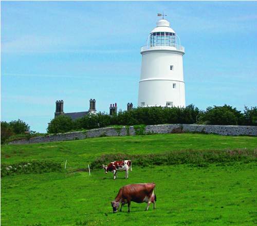
FIG 49. St Agnes: cattle grazing beside the lighthouse, May 2005. (Rosemary Parslow)
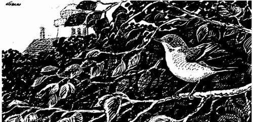
FIG 50. Pied flycatcher near St Agnes lighthouse. The gardens of the parsonage and the lighthouse attract many passage migrants. (D. I. M. Wallace)
Pool in the meadow (Fig. 51). Both the pools here (there is also a Little Pool nearby) are surrounded by grassland on low-lying land with the sea on two sides. The sea occasionally floods the meadow area, although recent sea defences have reduced the frequency. At other times the pools flood after heavy rain and the leat connecting Big Pool to the sea has to be opened at low tide to release the water. So, although usually freshwater, Big Pool may at times be slightly brackish. Around the pools are successive rings of vegetation: sea club-rush succeeded by saltmarsh rush, marsh pennywort, then creeping bent Agrostis stolonifera. Big Pool contains a few aquatic species, usually fennel-leaved pondweed but on occasion beaked tasselweed. The pool attracts very few breeding waterfowl, but is important at migration times. There are two resident Odonata species, common darter dragonfly Sympetrum striolatum and blue-tailed damselfly Isnura elegans. Frequently there are very large common eels in the pool and occasionally a heron Ardea cinerea will be seen standing in the pool, struggling to swallow one that has wrapped itself around its neck. These drawn-out battles between fish and bird can last for many minutes before the heron manages to swallow the fish or gives up and lets it go.
The meadow is also the local cricket pitch (as well as the tennis court and occasional helipad, especially in winter), with a species list that includes a
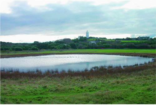
FIG 51. Big Pool and the chamomile cricket pitch, St Agnes, February 2004. (Rosemary Parslow)
number of rare and unusual plants including autumn lady’s-tresses, chamomile and several rare clovers. Most of the meadow sward around the cricket pitch is kept short by mowing, or elsewhere by rabbit and cattle grazing. The only site in Scilly for common adder’s-tongue fern Ophioglossum vulgatum is under bracken on the edge of the meadow. Nearby in the cart ruts left by tractors in the sodden turf can be found two species of spike-rush, slender spike-rush Eleocharis uniglumis and many-stalked spike-rush E. multicaulis, as well as another rarity, early meadow-grass, and tufts of the tiny club-rushes Isolepis setacea and I. cernua.
Just west of the meadow is the harbour of Periglis. Here are the former lifeboat house and the remains of the longest lifeboat slip in Scilly, although the shallowness of the incline meant it never functioned properly. Periglis is the main harbour for the islanders’ boats and is very sheltered from most directions. There is a low dune at the back of the bay with typical dune plants including sea-kale, sea bindweed Calystegia soldanella and strandline species where the sandy beach gives way to rocks and boulders towards the north in one direction and towards the quay in the other. Burnt Island is a small island that lies to the northwest of Periglis, joined to St Agnes by a reinforced boulder-filled gabion at Ginamoney Carn. The island is low-lying and rocky, mainly covered in maritime grassland, bracken and thrift. At the furthest extremity of Burnt Island is Tin’s Walbert, a large rock promontory that can only be reached at low tide.
To the east of the meadow is a large and very rocky bay, Porth Killier, and round the next promontory into Porth Conger is the main quay where passengers and freight are landed. South of the bar which links St Agnes to Gugh is the large inlet of the Cove, in which is found the very popular small bay of Covean. Besides attracting sunbathers to its warm, white sands, this can often be the stopping-off place for migrant birds, and sometimes there are willow warblers Phylloscopus trochilus, flycatchers and other birds flitting in and out of the tamarisks and snatching flies from the sand between the sunbathers. Just above the path from Covean to the Bar is a suite of fields with very sandy soils. Most of these have a particularly impressive arable weed flora and are often very colourful with corn marigolds, the ‘whistling jacks’ gladiolus Gladiolus communis byzantinus, fumitories and smaller tree-mallow.
The whole southern part of the island delights in the charming name of Wingletang Down, an extensive stretch of maritime heath with the twin bays of Wingletang Bay on the east and Porth Askin on the west, with the rocky promontory of Horse Point at the southern tip of the island where the land falls into the sea among short maritime grassland and a great chaos of tumbled rocks. Horse Point is almost separated from the rest of the island by the two bays and a narrow sandy neck of land, and it seems highly probable that one day it will eventually be cut through. In the middle of Wingletang Bay is Beady Pool, so named because it is where the small barrel-shaped brown beads from a seventeenth-century wreck have been found. At the back of the bay yellow horned-poppy, sea-kale and sea spurge surmount the low dune bank. Shore dock once appeared in a sand pit here (illicit digging possibly having exposed buried seed), but died out after a few years to reappear in a dune blow-out on the opposite side of the island beside Porth Askin; unfortunately it soon died out there as well. Wingletang Down is very important botanically: rarities such as orange bird’s-foot and small adder’s-tongue fern grow here, but it is also the only locality in Scilly for the very rare least adder’s-tongue fern, known in Britain only from here and the Channel Islands.
St Warna’s Cove is a rocky, south-facing bay on the west of St Agnes. This section of the coast is studded by a number of huge carns that continue right around the west side of the island (Fig. 52). The cove is overlooked by a curiously shaped rock called Nag’s Head on the heathland below the distinctive outline of the coastguard cottages (Fig. 53). And close to the shore is a stone-lined well that is possibly of great antiquity – it is reputed to be close to where the saint is supposed to have landed from Ireland in his coracle. Traditionally pins should be dropped in the well to encourage storms to drive a wreck ashore! Castella
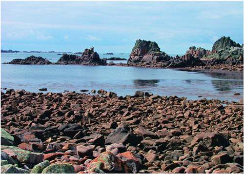
FIG 52. Granite carns at St Warna’s Cove, St Agnes, August 2003. (Rosemary Parslow)
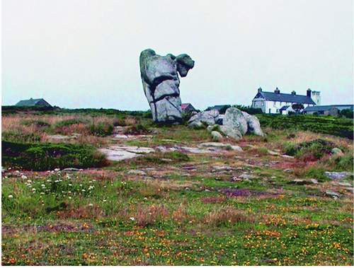
FIG 53. The Nag’s Head and the coastguard cottages, St Agnes, July 2002. (Rosemary Parslow)
Downs, an area of rabbit-grazed coastal grassland and rough heathland further to the west, is where the Troy Town maze, actually a pebble labyrinth, is set in the turf
Gugh
The island of Gugh might be described as the sixth inhabited island, but it is usually included with St Agnes. At low tide you can cross the Bar – a sand bar, strictly a tombolo – from one island to the other. Immediately at the end of the Bar is a small area of dune and dune grassland merging into the maritime grassland fringe around the island. A dense edge of sea-holly Eryngium maritimum marks the dune edge and both sea and Portland spurge are found here with sea bindweed and other coastal plants. The grass bank at the top of the Bar is one of the few places where wild thyme grows; earlier in the year western clover and early meadow-grass are also abundant here. This is another beach where the lesser cockroach has been found. The majority of the island is wind-pruned waved heath or dense gorse and bracken, with maritime grassland around the coastal fringe and on the north and southwest of the island. The summit of Gugh
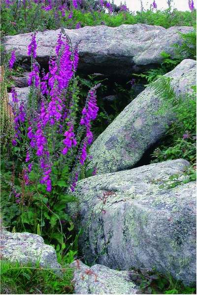
FIG 54. Named after islander Obadiah Hicks is Obadiah’s Barrow, an entrance grave on Gugh, half hidden among foxgloves and wall pennywort. June 2003. (Rosemary Parslow)
is remarkable for the number of archaeological remains that are still visible: on top of the hills that form the spine of the island are a series of Bronze Age barrows, remnants of walls and a standing stone known as the Old Man of Gugh. Another well-known barrow, Obadiah’s Barrow, lies among dense gorse on the side of the hill (Fig. 54). For a small island there is an extensive list of rare and unusual plants, lichens and invertebrates.
The former Gugh farm occupies the central area just north of the neck across the middle of the island, between the two heathy hills that make up the body of the island. Two houses now stand there; they were built by a Mr Cooper in about 1920 and they have strange curved concrete roofs, like upturned boats, designed to withstand gales (Fig. 55). When Cooper died he was buried on the island. On the east coast of Gugh is a bay with dazzling white sand called Dropnose Porth. This curious name occurs elsewhere in Scilly, so maybe this is a humorous, descriptive reference to a nearby rock. Many of the granite carns and rocks have been eroded into fantastic shapes. There is a rock near Kittern Hill at the north end of Gugh that, seen from the sea, appears to have been sculpted into a likeness of Queen Victoria – though from a slightly different angle it becomes a Red Indian brave!
The sandy neck between the two hills formed from blown sand has an unusual flora. Growing among the bracken beside the path are dog roses Rosa
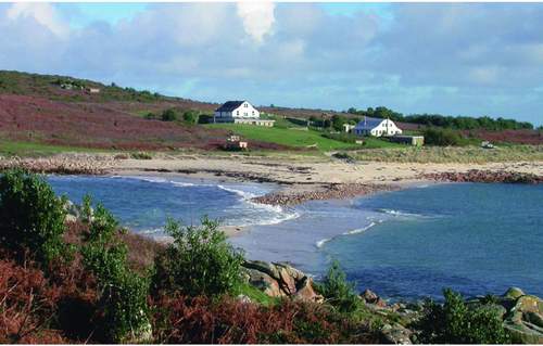
FIG 55. The tide just covering the Bar (strictly a tombolo) from St Agnes to Gugh, November 2002. (Rosemary Parslow)
canina and an unidentified yellow rose (presumed an escape from cultivation). Balm-leaved figwort is very common here, despite not being found elsewhere on the island. Another plant found in this vicinity is the alien Argentine dock Rumex frutescens. This grows on the edge of the abandoned sand pit, originally dug as a reservoir. In the field below the Gugh houses from about 1933 viper’s-bugloss Echium vulgare, wild mignonette Reseda lutea and common melilot Melilotus officinalis were found, although not all have been seen recently. Their presence in the field has been attributed to the use of shoddy (a high-nitrate manure deriving from the wool industry) before 1933. In the 1960s this neck area was close-cropped grassy sward, a good place to find mushrooms, where thousands of garden tiger Arctia caja caterpillars would swarm and cuckoos Cuculus canorus would arrive to feed on them, and where wheatears would also appear on passage (J. Parslow, in litt.). When myxomatosis reduced the rabbit population, the neck became overgrown with brambles and bracken, and the open turf and the grass tennis court that was there all disappeared from view (W. Hick, personal communication).
Along the top of Gugh, just above Obadiah’s Barrow, there was a heath fire in October 1972 that burned down through the shallow peat soil to the granite. As a result recovery has been slow and even now traces of the fire can still be seen, in blackened stems of gorse and bleached rocks. There have also been changes in the vegetation: yellow bartsia Parentucellia viscosa, for example, became very common in the burnt area and for a time English stonecrop and bird’s-foot-trefoil were dominant plants on the bare ground. Elsewhere heathland extends along the crest of the island, both north and south of the ‘neck’. Sometimes the rare orange bird’s-foot can be found on one of the larger carns in the southern half of the island. Here too are extensive colonies of lesser black-backed gulls Larus fuscus, herring gulls L. argentatus and a few great black-backed gulls L. marinus. It is wise to avoid the gull colonies during the breeding season, as the gulls are likely to ‘dive-bomb’ people who approach too close to their nests, and can be very intimidating.
Small adder’s-tongue fern has been found on at least one place on Gugh in the past, but has now not been seen for about a decade. This is not unusual with this group of ferns, so it could reappear again if conditions are suitable. Other rarities, for example golden hair-lichen, certain invertebrates and migrant birds are found on Gugh, just as they are on St Agnes. Manx shearwater and storm petrel Hydrobates pelagicus no longer breed, but on dark nights the shearwaters may still be heard revisiting their former haunts. For many years there has been a colony of kittiwakes under the cliffs, but recently the colony seems to have moved elsewhere.
Other than rabbits, there are now no grazing animals on Gugh. Cuckoo, the little donkey described by Leslie Thomas (1968), and Demelza the house cow both left in 1974. Cloven-hoofed animals failed to thrive on Gugh due to cobalt deficiencies in the soil, and the animals had to be given supplements (W. Hick, in litt.). Gradually the sandy neck area largely scrubbed over and there is no longer the wide swathe of short grassland that was there in the 1960s. Other farming projects since then have failed, so there are abandoned bulb and asparagus fields which have gone back to dense bracken, but where a flush of daffodils or wisps of asparagus fern still appear in season. Some of the abandoned bulb fields on the farm still have remnant hedges and, where the rabbits have been digging, some of the arable plants, along with both common and orange bird’s-foot, may reappear.
Cuckoo the donkey is a reminder that of all places in Scilly, Gugh often used to have the largest and noisiest population of cuckoos, apparently attracted by the extraordinary numbers of garden tiger and other large caterpillars found there some years. They would fly over the island and the Cove in spring in noisy display, their cuckooing echoing across the water until in the past some islander, driven demented by them, would take the law into his own hands and silence them with a shotgun.
CHAPTER 7 The Uninhabited Islands
Nine leagues from the farthest westerly point of England, there is a space of sea, which, in a circuit of seventy miles, embraces a very great number of small islands and rocks, a great part of which are constantly covered with water, and are the cause of more ship wrecks than happens perhaps in all the other seas of Europe together. These islands, which, by modern geographers are called the Sorlings, are, by English, more commonly known by the name of Scilly.
Cosmo III, Grand Duke of Tuscany (1669)
WHAT CONSTITUTES AN island in Scilly is subject to considerable difference of opinion. Each writer seems to have had their own idea as to how many islands there are, their views mostly coloured by their particular interest. In 1542 John Leland estimated there were 140 islands ‘that grew grass’; in 1607 William Camden described Scilly as having ‘near 145 islands covered with grass or greenish moss’, but this is rejected by Bowley (1990) on the grounds that many of the smallest islands only had lichen present. Bowley defined an island as being land surrounded by water at high tide, supporting land vegetation at all times and locally accepted as an island. He then lists 54 islands that fit his criterion of having land vegetation. For the purpose of this account the definition of an island has more to do with its natural history, so in this case the designation is essentially pragmatic: it includes any land obviously separate at high water where any kind of wildlife is present. This means all types of islands are included, not just those with higher vegetation growing on them, and it includes bare rocky islets that have colonies of breeding seabirds or are used as hauling-out places by grey seals.
Most of the uninhabited islands can be considered in three main distinct geographical groups, each having their own special character. Of course the name ‘uninhabited’ is something of a misnomer. Rather they are islands not inhabited by humans, as there are plenty of other inhabitants – birds, rabbits and other animals. At the furthermost southwestern extremity of the archipelago, completely exposed to the full force of the sea and the prevailing winds, lies the Bishop Rock, surmounted by the lighthouse (Fig. 56). Included in one group with the Bishop Rock, lying just 2.5km away, is the low mass of jagged rocks,
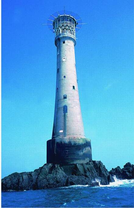
FIG 56. Bishop Rock Lighthouse towers 49 metres above its rock base. May 2005. (Rosemary Parslow)
reefs and small craggy islands that form the Western Rocks. Continuing the semicircle inwards is the larger island of Annet, low-lying and exposed but large enough to be well vegetated. The Norrard or Northern Rocks also lie to the west of the main group of islands and in the path of the worst storms from the west. Islands in this group are also extremely rocky and bare, like the Western Rocks, just the tips of a more extensive mass of granite reefs hidden below the sea. The harsh contours of the Norrard Rocks and the Western Rocks support very few higher plants, unlike the Eastern Isles and the St Helen’s group (including Round Island and Teän), which seem much softer islands with their gentler contours and vegetation cover. The Eastern Isles are the most sheltered of all the uninhabited islands, protected by the half-circle of the inhabited islands.
The duplication of names of rocks and islands in Scilly can be confusing. For example there are two Green Islands, two Plumb Islands, two White Islands, and so on. With rocks it becomes even more confusing: twelve Round Rocks, four Seal Rocks, five rocks called Biggal and many duplications in the names of bays and other features. Over two hundred islands have some known natural history interest, and the most significant of these are described below.
SAMSON, WITH PUFFIN, WHITE, GREEN AND STONY ISLANDS
Samson is the largest of the uninhabited islands, 36 hectares above MHWS in extent and just over a kilometre in length, consisting of twin hills linked by a sandy neck. Along the eastern side of the island are wide sand flats stretching across the shallow channel to Tresco. At low tide much of the flats is exposed, revealing the remains of ancient walls. The twin granite hills top 30 metres and have archaeological remains on their summits (see Chapter 3 for more about the history of Samson). Many of the lower slopes of the island are covered in deeper soils, now mostly under bracken. Ruins of several abandoned cottages from the time the island was inhabited can be seen, mainly on the north slope of South Hill. The island was finally evacuated in 1855. Some of the field walls are still standing, especially on South Hill, and are seen clearly when the bracken has died down. Other walls may have been robbed to provide stone for the wall of the deer park. Although the 3.5ha enclosure on South Hill was abandoned by 1860 when the deer escaped, the wall is still clearly visible. The few trees found on the island, tamarisk and elder, are associated with the former inhabitants, as are plants such as primroses that probably originated in their gardens. A sand bank at the northeast corner of Samson is the usual landing place for visitors, and very popular for sunbathing and picnicking. Behind the landing is an area of sand dune and low scrub with North Hill rising up behind (Fig. 57). On top of the hill and along the ridge is an area of heathland, much of which has been burned on a number of occasions, exposing the line of archaeological sites along the top. The slopes of the hill and much of the rest of the island are covered in dense stands of bracken. South Hill has vestiges of heathland, but
Конец ознакомительного фрагмента.
Текст предоставлен ООО «ЛитРес».
Прочитайте эту книгу целиком, купив полную легальную версию на ЛитРес.
Безопасно оплатить книгу можно банковской картой Visa, MasterCard, Maestro, со счета мобильного телефона, с платежного терминала, в салоне МТС или Связной, через PayPal, WebMoney, Яндекс.Деньги, QIWI Кошелек, бонусными картами или другим удобным Вам способом.

