Полная версия:
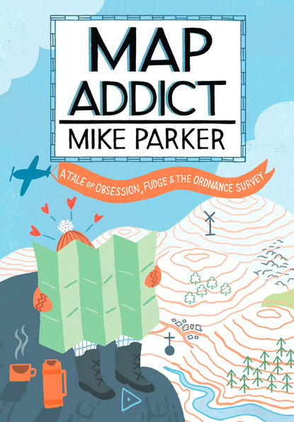
Map Addict
The 1884 Washington conference came exactly a year after the 7th General Conference of the European Arc Measurement, held in Rome. It was at this geodetic gathering that the French had secured international agreement to use their metre as the global standard unit for measuring length. Their definition of a metre—one ten-millionth of the section of their meridian as it passed over the land between Dunkirk and Barcelona—had been achieved by impeccably scientific means that demonstrated to all the advanced nature of their geodetic powers. Using the line that passed through the Paris Observatory to calculate the metre also subtly cemented that meridian in the world’s consciousness, at a time when calls were becoming ever louder to create one super-meridian, from which all else would be calculated. To decide where that should be was the raison d’être of the Washington conference, twelve short months later. The French must have arrived in America feeling that the prevailing wind was well and truly in their sails.
Not for long, though. There had evidently been some anglophonic stitch-up going on behind the scenes between the host Americans and their British cousins. Use of the Paris Meridian to establish the world’s measuring stick was employed not in advocacy of its adoption as the Prime Meridian, but as a sly argument by the English-speakers against such an eventuality. After all, they cried, it’s someone else’s turn! You got the metre, now be a jolly chap and leave go the damned meridian, won’t you? Of course, the irony should not escape us that this Anglo-American pincer movement, so much of which depended on their reminding delegates of the recent French victory in measuring the world, came from two countries who have had as little to do as possible with the metric system ever since. Even today, the USA remains one of only four countries on Earth officially using imperial weights and measures (it’s an unlikely foursome: the others being Burma/Myanmar, Yemen and Brunei), and with its ever-growing ranks of metric martyrs, save-the-pint campaigners and kilometre refuseniks, it can hardly be said either that Britain has embraced the New (well, 1883) World Order.
At Washington, the French swiftly realised that no one else was going to support the Paris Observatory as the proposed site of the Prime Meridian, so they set about plan B, namely the standard fallback position that, if they weren’t to have the prize, they must do all they could to scupper the chances of the British. We would doubtless have done exactly the same in their tiny shoes. It wasn’t just the French performing beautifully to their own national stereotype: the conference minutes are a quite hilarious catalogue of every nationality living up to its most dastardly clichés. The Americans, swaggering into their role as world-leaders-in-waiting, were bullish, yet smarmy, and masters of manipulation, particularly of the easily flattered British. To that end, the Americans played the good guy, genial hosts with absolutely no self-interest in the process, while shooting across everyone’s bows at the very first session with a clear reminder of their latent muscle. The chairman of the US delegation, Admiral C. R. P. Rodgers, was elected President of the Conference. In his opening address, he declared:
Broad as is the area of the United States, covering a hundred degrees of longitude, extending from 66° 52’ west from Greenwich to 166° 13’ at our extreme limit in Alaska, not including the Aleutian Islands; traversed, as it is, by railway and telegraph lines, and dotted with observatories; long as is its sea coast, of more than twelve thousand miles; vast as must be its foreign and domestic commerce, its delegation to this Congress has no desire to urge that a prime meridian shall be found within its confines.
The minutes do not record if he expounded this while stroking a white cat in his lap.
Rodgers’ statement made clear where the host delegation were to place their support when it came to deciding the location of the Prime Meridian: Greenwich. Indeed, it was only on the second day of the conference that American delegate Naval Commander W. T. Sampson jumped the gun and formally proposed it, stating:
As a matter of economy as well as convenience, that meridian should be selected which is now in most general use. This additional consideration of economy would limit our choice to the meridian of Greenwich, for it may fairly be stated upon the authority of the distinguished Delegate from Canada that more than 70 per cent of all the shipping of the world uses this meridian for purposes of navigation.
The French delegation were horrified, and filibustered the proposal off the table, with a speech by their prime delegate, M. Janssen, the Director of the Paris Observatory, that culminated in his demanding more time to consider the question but which, to reach that point, took well over an hour as he pondered the enormity of the matter in hand. He voiced their opposition to Greenwich in the most tremulously righteous terms:
This meridian, instead of being chosen with reference to the configuration of the continents, is borrowed from an observatory; that is to say, it is placed on the globe in a hap-hazard manner, and is very inconveniently situated for the function that it is to perform…Instead of profiting by the lessons of the past, national rivalries are introduced in a question that should rally the goodwill of all…Since the report considers us of so little weight in the scales, allow me, gentlemen, to recall briefly the past and the present of our hydrography, and for that purpose I can do no better than to quote from a work that has been communicated to me, and which emanates from one of our most learned hydrographers. ‘France,’ he says, ‘created more than two centuries ago the most ancient nautical ephemerides [tables showing coordinates of celestial bodies at particular times] in existence. She was the first to conceive and execute the great geodetic operations which had for their object the construction of civil and military maps and the measurement of arcs of the meridian in Europe, America and Africa. All these operations were and are based on the Paris meridian’. If another initial meridian had to be adopted, it would be necessary to change the graduation of our 2,600 hydrographic plates; it would be necessary to do the same thing for our nautical instructions, which exceed 600 in number.
Although happy to have a good sulk about how much more inconvenient a change of meridian would be for the French than anyone else, Janssen knew well that there was little mileage in further banging the drum for the Paris Meridian, whose cause was already lost. He seized instead on a more nebulous point that, he hoped, would sink the cause of the British, demanding of the conference that ‘the initial meridian should have a character of absolute neutrality…and in particular especially should cut no great continent—neither Europe nor America’. While Britain pretended to be above such squalid argument, their attack-dogs, the American delegation, weighed in with ready answers: ‘The adoption of the meridian of Greenwich has not been sought after by Great Britain,’ Commander Sampson boomed back. ‘It was not her proposition, but that she consented to it after it had been proposed by other portions of the civilised world.’ How very gracious of us: we can only imagine the holier-than-thou expressions adopted by the British delegation at this point. In his opening address, the American Admiral Rodgers had presaged this question of neutrality:
Should any of us now hesitate in the adoption of a particular meridian, or should any nation covet the honor of having the selected meridian within its own borders, it is to be remembered that when the prime meridian is once adopted by all it loses its specific name and nationality, and becomes simply the Prime Meridian.
Absolute horse-shit of course, but high-minded horse-shit of the finest grade. The Americans were really getting the hang of this diplomacy lark.
M. Janssen was the undoubted star of the event, able to turn in grandiloquent speeches, on any topic, that lasted an hour or two. Realising that the neutrality argument was all that lay in the way of the adoption of Greenwich, he worried at it like a starving poodle:
An immense majority of the navies of the world navigate with English charts; that is true, and it is a practical compliment to the great maritime activity of that nation. When this freely admitted supremacy shall be transformed into an official and compulsory supremacy, it will suffer the vicissitudes of all human power, and that institution [the meridian], which by its nature is of a purely scientific nature, and to which we would assure a long and certain future, will become the object of burning competition and jealousy among nations.
Anyone particular in mind, Monsieur?
Professor J. C. Adams, of the British delegation, waspishly replied that Janssen’s ‘eloquent address, in so far as I could follow that discourse, seemed to me to turn almost entirely upon sentimental considerations’, and reiterated the point of practicality, that the most ‘convenient’, i.e. widely used, meridian would make the most sense. He didn’t sully his purity by naming it; he didn’t need to.
In turn, Janssen rebuffed Adams in the politest way possible, while managing a few withering digs at his British counterparts (‘and we are still awaiting the honour of seeing the metrical system for common use in England’). He protested—rather too much—that the French objection was nothing whatsoever to do with ‘national pride’ and questioned the idea of the ‘convenience’ of the Greenwich Meridian. To whom exactly, he postulated, was it convenient? Ah, the Brits and the Yanks: the ‘advantage is to yourselves, and those you represent, of having nothing to change, either in your maps, customs or traditions—such a solution, I say, can have no future before it, and we refuse to take part in it’. He persevered in even darker tones: ‘You see, gentlemen, how dangerous it is to awaken national susceptibilities on a subject of a purely scientific nature.’ Ratcheting up his rhetorical powers, he concluded one particularly long speech with a flourish: ‘Whatever we may do, the common prime meridian will always be a crown to which there will be a hundred pretenders. Let us place the crown on the brow of science, and all will bow before it.’
Janssen’s sterling verbosity was only delaying the inevitable, so, realising that they were backed into a corner, the French hit their nuclear button, issuing veiled threats that they might walk out of the conference and then, when that went almost unnoticed, strident complaints about the standard of translation into their language at the conference. They demanded a recess in order to find a better French stenographer, a process that kept the conference from reconvening for a full further week. When all the delegates reassembled on Monday 13 October, everyone’s positions, after seven days of backstage back-stabbing, had coagulated into immutability.
The French kicked off proceedings by playing what was their only remaining decent card, the demand for the ‘absolute neutrality’ of any chosen meridian. It was put to the vote and heavily defeated by 21 to 3. As a faintly placatory gesture, Sandford Fleming, one of the British delegation, invoked the idea of placing the Prime Meridian 180° from Greenwich, thus, he said, giving it some political neutrality and positioning it largely in the uninhabited Pacific Ocean. The idea didn’t mollify the French at all, who sneered that even if the Prime Meridian was 180° from Greenwich, it was still the Greenwich Meridian in all but name, only in reverse.
This proposal from the British delegation was typical of our fauxhumble demeanour at this stage in the proceedings: it’s easy to be magnanimous when you’re clearly winning, especially in a contest that you’re feigning absolute disinterest in. The British vat of oil to pour on troubled waters was soon generously employed again, as the French and Spanish reminded delegates that their governments fully expected Britain and the USA to join the metric system, if not in a quid pro quo for the adoption of Greenwich, then certainly in the same spirit of global good manners and scientific unity. One of the British delegation, General Strachey, smoothly replied:
I am authorised to state that Great Britain, after considering the opinions which were expressed at Rome, has desired that it may be allowed to join the Convention du mètre…[and] that there is a strong feeling on the part of the scientific men of England that, sooner or later, she will be likely to join in the use of that system, which, no doubt, is an extremely good one.
In other words, we’ll get home and do precisely nothing about it for a century, but thank you so much for your concern. Stuff you with a smile, Monsieur.
The definitive vote on adopting Greenwich loomed, and the French made one last desperate bid to prevent it. The loquacious M. Janssen deferred to his colleague M. Lefaivre to make their final plea. ‘The meridian of Greenwich is not a scientific one,’ piped Lefaivre, ‘and its adoption implies no progress for astronomy, geodesy or navigation.’ It was only ‘convenient’, not scientific, a fact that
our colleague from Great Britain just now reminded us of by enumerating with complacency the tonnage of British and American shipping…Science appears here only as the humble vassal of the powers of the day to consecrate and crown their success. But, gentlemen, nothing is so transitory and fugitive as power and riches. All the great empires of the world, all financial, industrial and commercial prosperities of the world have given us a proof of it, each in turn.
This was the sound of grand nobility in defeat, for the vote was then taken and Greenwich confirmed as the world’s Prime Meridian by 22 votes to 1, with two abstentions. Only San Domingo (the island of Hispaniola) voted against, with Brazil and France abstaining. They didn’t want to look like sore losers. Or rather, they were saving that for later.
After further lengthy arguments about how to calibrate degrees from Greenwich, and how to calculate time zones, the French asked for another deferment of the conference. They returned six days later with a small bombshell of a proposition: that the metric system—which, they reminded delegates, everyone had spoken so voluminously in favour of—should be extended from the measurement of length, volume and weight and into the realms of degrees, angles and time. Greenwich might be getting the line through it, but at least the grid of longitude and the calibration of the day that spun off it might be expressed in a French way, or at least in a way that was guaranteed to piss off the Anglo-American alliance. The British and the Americans cried foul, that such a decision was beyond the remit of the conference.
Style over substance: the Paris meridian
For the first time in weeks, the French smelled English-speaking blood and pressed home their slender advantage, demanding a vote on whether or not a vote could be taken on the topic. It was close. Thirteen countries agreed that the issue of metricising time and angles could be considered; nine, Britain and the US included, voted against. Two abstained. So, as eager not to appear bad losers as had the French been on the Greenwich vote, the Americans and British then ostentatiously supported the metric system in the subsequent vote. In fact, no one voted against it—not that that made the faintest bit of difference in actually making it happen.
Flushed with their pyrrhic victory, the French demanded a further adjournment to the conference, which briefly reconvened two days later before its final adjournment, for nine days, in order that the conference protocols could be drawn up, in English and, of course, in French. On the first of November, a month to the day since the delegates had first gathered, the conference closed in a mutual orgy of back-slapping and vainglorious speeches about how the international community was united as never before and that they had made history. Thankfully, the sagging balloon of hot air was peremptorily pricked by the very last contribution noted in the conference minutes: the ever vocal M. Janssen of the French delegation complaining about the standard of French used in their translations.
As expected, the French reaction to the conference’s decision was to ignore it for as long as they possibly could. The Paris Meridian was still marked as 0° on French maps until 1911, and even beyond that, they kept refusing to refer to the notion of Greenwich Mean Time, preferring instead to name the concept the altogether snappier ‘Paris Mean Time diminished by 9 minutes 21 seconds’. It’s a shame it didn’t catch on: PMT has such an appropriate ring to it for matters of timekeeping. Even though the Paris Meridian has long been shunted into the sidings, the French still keep polishing it and showing it off to the world like a priceless relic. One of their main millennium projects was to plant lines of trees the entire length of France along their old meridian line. It might no longer be functioning, but hey, you could see it from space, or at least if you look closely enough on Google Earth in a few decades’ time. To a chippy Brit (and, when it comes to any dealings with the French, that’s most of us), the project smacked of dismissive looking down the Gallic nose at the lack of presentational flair that attends our meridian line.
The world’s timekeeping and cartographic staff it may be, but as the Prime Meridian enters Britain in the retirement town of Peacehaven on the Sussex coast, it’s marked only by a dowdy obelisk and the Meridian Centre, a deathly 1970s shopping mall with the unmistakable aroma of incontinence. Two hundred and three miles due north, it leaves English soil in similarly dreary fashion, on a beach just south of the Sand-le-Mere caravan park, near Tunstall on the Holderness coast of Yorkshire’s East Riding. Britain’s bleakest coast is also
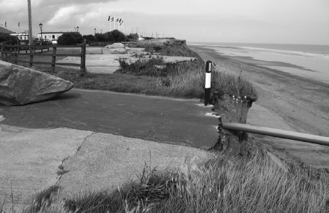
Substance over style: where the Prime Meridian enters England at Tunstall, East Yorkshire
the fastest-receding in Europe, where houses and roads tumble regularly over the edge, leaving their forlorn traces to be washed over by a freezing sea the colour of a river in high flood. In the circumstances, the great local millennium project—placing a huge carved boulder on the cliff top to mark the point at which the global meridian arrives in its home country from the North Pole—was something of a triumph of optimism over experience. Instead of lasting the full thousand years, it managed just three, disappearing over the muddy cliff in a storm in January 2003. In between these two inauspicious gateposts, as well as the whistles and bells of Greenwich itself, the meridian is marked by a number of plaques, columns, archways and, in Cambridgeshire, a line of daffodils planted by Boy Scouts. It’s either disarmingly modest or just a bit crap. Either way, it’s British through and through.

If—and, frankly, it’s a bloody big if—we accept British pre-eminence in modern mapping owing to the adoption of the Greenwich Meridian as the gold standard for measuring lines on a map, then one event gave birth to this certainty. That was the creation of an earlier imaginary line on the landscape, the first precisely calibrated base line across a stretch of English countryside, from which all initial triangulations were taken to produce what soon became the Ordnance Survey. It took place in the summer of 1784, and for reasons that are also gloriously British: once again, a fierce spirit of one-upmanship against the French and a supremely thin-skinned paranoia that they were insulting us.
We had a lot of making up to do; by the late eighteenth century, French map-making was leagues ahead of that of its clod-hopping British cousin. Nearly a century earlier, their experiments in establishing accurate lines of longitude and latitude had proved that the world was an oblate spheroid, rather than a perfect sphere, which had tremendous impact on the precise measurement of relative distances, radically altering the shape and size of France itself as presented on a map. Coupled with advances in triangulation and surveying, the Académie Royale produced, in 1789, by far the finest and most ambitious cartography that had ever been made of one country: a complete set of 180 maps, covering all of France, at a scale of 1:86 400, just under one and a half miles to the inch. Even the detail on the maps was starkly different: while we were still delineating our upland areas with crude shading or lumpy molehills scattered over the landscape, the French were developing sophisticated systems of hachures—groups of parallel lines to indicate height—before pioneering the use of contour lines on some maps from the 1750s.
The year 1789 is better remembered in France for rather bloodier reasons than the publication of the national map, the Carte de Cassini as it became known, after César-François Cassini de Thury, the Director of the Paris Observatory and its principal progenitor, who had died of smallpox in 1784, leaving his son to continue the work. The new revolutionary government looked with grave suspicion on anything royale, the Académie included, although they were more than delighted with the maps and promptly took over all responsibility for their production and publication. The Académie Royale was closed down (to resurface a few years later as the more egalitarian Académie des Sciences), Cassini junior was imprisoned, while Académie director Antoine Lavoisier was carted off to the guillotine. It was at just this moment in history that the British were starting to get their act together, and, aided by the chaos in France, were soon able to outstrip their neighbours. Though, as ever, it took some pompous prodding by the French to sharpen us up.
That came six years before the Revolution, in the shape of a missive from Cassini de Thury to King George III, in which he loftily pointed out that the world’s two principal meridians, those of Paris and London, were out of kilter in both longitude and latitude. His inference was that, thanks to the superior surveying and triangulation of the French, the mistake was almost certainly on our side of the Channel, and would His Majesty care do something about it? He further rubbed salt into the wounds by pointing out that he himself had checked the trigonometry on the French side all the way up to the Channel coast, and, using a telescope, had established many landmarks on the English side that could be useful if we could be bothered to do a proper survey. The King’s principal Secretary of State, Charles James Fox, passed on the letter to Sir Joseph Banks, President of the Royal Society in London. Many of its members were outraged by the slurs it contained, the Astronomer Royal, the Reverend Doctor Nevil Maskelyne, firing off a hasty rebuttal of the French claims. But there was one Fellow of the Royal Society who received the news with equanimity, bordering on glee, for he knew that this was the chance for which he had been waiting for decades.
We know frustratingly little about Major-General William Roy (1726-90), a map addict of impeccable credentials and the father of the Ordnance Survey. No portrait survives of him, few biographical details have come our way, but, from his plans, letters and publications, we can see a man utterly driven by maps and an insatiable urge to make them ever better. He started in his native Scotland, working with the surveying crews that had been drafted in as a response to the Jacobite uprisings in the Highlands of the 1740s. The official response was the same as always: go deep into enemy turf, build roads and military outposts, move the population to where they could better be tracked, and, most importantly of all, comprehensively map it. For years, this was Roy’s day job, though, as a sideline, he also worked obsessively to map the Roman remains of Scotland, for they had employed much the same techniques in suppressing the clans fifteen centuries earlier. There’s not much doubting what his specialist subject would have been on Georgian Mastermind.

