
Полная версия:
Britain’s Structure and Scenery
CHAPTER 6
THE WORK OF THE SEA
THE extraordinarily varied character of the sea coasts of Britain and the variety of habitats which they afford to both plants and animals, with the consequent enrichment of our fauna and flora, give a special interest and importance to the story of the work of the sea in the building of the British Isles.
It is now generally agreed that ocean currents play but a very small part in the erosive and transporting work of the sea and that the effects of tidal movements are limited to a few special cases—notably tidal scour in confined estuaries and straits. The work of the sea is primarily through wave action—to some extent through the hydraulic forces engendered by the movement of great masses of water, but far more through the arming of the waves with quantities of rocks, stones, gravel and sand.
The waves of the sea are primarily wind-waves ; they are caused by the disturbance of the surface by wind but, once formed, waves may travel far beyond the area where they were generated—hence “swell” or “ground-swell” unaccompanied by wind. It is, of course, well known that there is no forward movement of the water in wave action, except where the waves are breaking on the coast. The vertical range of motion, in other words the height which waves may reach, is commonly much exaggerated. Waves which are as much as 50 feet from trough to crest are decidedly large, probably quite exceptional even in the open ocean. At a depth of 100 feet the water is little disturbed, at a depth of 500 feet it is doubtful whether there is enough movement to disturb even the finest mud. There is thus a fundamental difference between sub-aerial denudation, which takes place at all heights from sea-level to the tops of the highest mountains, and marine denudation which acts on a very restricted vertical plane above or below the surface level of the water, The maximum effect is where sea meets land—between the tide marks and just above or below.
Consider what happens at the base of cliffs. Angular blocks of rock and stones fallen from the face of the cliff are picked up by the waves and hurled against the base of the cliffs which they thus tend to undercut,
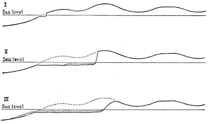
FIG. 18.—Sections showing the Formation of Cliffs These sections illustrate the plane of marine erosion (see Plates 3 and XX A) and the way in which the cliffs are cut back and a submarine peneplane formed.
much in the manner of coal-cutting machinery at the base of a coal seam. Blocks from above then split off along joints and fall by the force of gravity ; where there is a dip of the rocks seawards great masses may slide down the bedding planes. The latter effect is well seen where rock overlies clay the surface of which becomes slippery and acts as a greased plane—hence the constant slips along the south coast of the Isle of Wight and between Dover and Folkestone, in each of which cases chalk overlies gault clay. Plate V shows the famous under-cliff, west of Ventnor in the Isle of Wight. On the shore between the tide marks the rock fragments are rolled against one another and quickly reduced to rounded boulders, pebbles and sand. These, rolled backwards and forwards between the tide-marks and later dragged below low tide-mark enable the sea to level off its wave-cut platform. This is illustrated in Plate 3. The particularly interesting case of undercutting of massive limestone shown in Plate XXA is partly due to the small tidal range and the consequent concentration of erosion along one plane.
Thus the effect of the sea round the coasts may be described as the
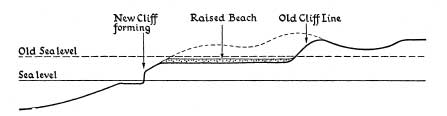
FIG. 19.—Section through a Raised Beach. This is a diagrammatic representation of the scene shown on Plate XI
creation of a platform, a wave-cut rock bench, on which is distributed a veneer of sediments made in the process. The process of its development is shown diagrammatically in Fig. 18. This shelves gently seawards under the water and passes imperceptibly into what is called the Continental Shelf. This is a great shelf found round most of the lands over which the sea is less than 600 feet deep.
The surface of the continental shelf is, normally, very gently undulating through relative resistance of the solid rocks. It is, in fact, a peneplane formed by the work of the sea. Even the slightly irregular denuding action of the sea may result in swellings of the floor which just give rise to shallow areas or may reach the surface as islands. Just as the sea in cutting back a cliff may leave a stack or an island, so in the age-long process of marine peneplanation certain upstanding masses may have been left as islands—it may be isolated and far from land. Where this is the case there is usually an explanation in the hardness or resistance of the rocks of which they are composed. The Scilly Isles are thus the protruding surfaces of an almost submerged granite mass comparable with that of Land’s End and from which the surrounding sedimentary rocks have been removed. The isolated mass of Rockall far away in the Atlantic off the north-west coast of Scotland consists of a particularly tough micro-granite and the same is true of Ailsa Craig near the entrance to the Firth of Clyde south of Arran. The celebrated St. Kilda is the largest of a group of sixteen islets rising from the continental shelf. They owe their origin largely to the resistant character of the Tertiary igneous rocks of which they are composed. Three of the small islands of the St. Kilda group are shown in Plate 32A and Stac Lee in Plate XXXII.
It follows that the floor of the “epicontintental” sea around the continents—that is the continental shelf—is sometimes interrupted by rocky masses which are, in fact, the “monadnocks” in course of evolution. It is probable that the solid rocks crop out over considerable parts of the sea-floor, uncovered by sediments, and these “rocky grounds’” are well known to fishermen. Where the rocks are hard and jagged trawling becomes impossible because of the tearing of the nets on the projecting rocks. Over very large areas, however, the continental shelf is covered by a veneer of sediments laid down by the sea itself and derived both from the nearby land by wave action and from the smoothing of the shelf itself as well as from sediments brought down from the heart of the land masses by rivers or icesheets. There is normally a gradation from the coarse shingle and stones of the beach near high-water mark, to sand, becoming finer seawards, which in turn passes into silt and mud. This sequence, however, is frequently varied or even reversed: the coastline may yield little or no coarse sediment ; rivers may bring down quantities of mud which becomes spread over a wide area ; outcrops of rock on the sea floor may yield local spreads of coarse material; and one may get sandy beaches. There are also more local or special conditions which result in variation in the form of the sea floor and its deposits. An interesting case is where icebergs broken off from land ice and bearing a burden of boulders and stones, both on the surface and frozen into the ice, meet warmer water. The icebergs melt and their burden is dropped on the sea floor. This is happening to-day in the Grand Banks area off Newfoundland and it must have happened extensively in the seas round the British Isles during and after the Ice Age. Indeed, boulders floated by ice from distant sources are found in some of the raised beach deposits along the shores of the English Channel.
The variety of habitat for marine bottom-living creatures in the shallow water of the continental shelf, is more than paralleled by the variety of habitat along the sea-shore itself.
Broadly speaking, any stretch of coastline is either one of erosion or of deposition and along such a varied coastline as that of the British Isles the conditions change with great frequency. A cliff coast is obviously an erosion coast and a high or irregular cliff line may be taken as indicative of long-continued erosion. Coast erosion was the subject of an exhaustive inquiry by a Royal Commission which reported in 1911 and much attention was given to the rate of cliff erosion.
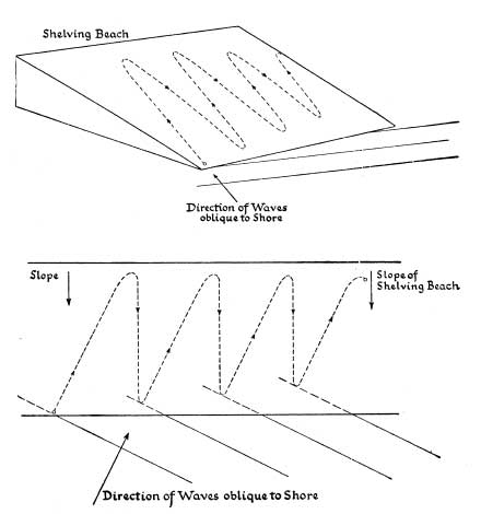
FIG. 20.—Diagrams showing the Drift of Shingle along a Shelving Beach. In each diagram the dotted line shows the course of a single pebble. It is thrown up the beach parallel to the direction of the prevailing waves but is dragged down the beach roughly parallel to the slope of the beach by the force of gravity. As the process is repeated the pebble works its way, with all its fellows, along the shore. If groynes are erected, this longshore drifting is partly arrested (Plate IX).
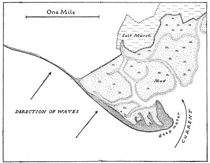
FIG. 21.—A Shingle Spit and Salt-Marshes Hurst Castle Spit, Hampshire
The chalk cliffs of the Strait of Dover appear to be receding at a rate which suggests the widening of the Strait by half a mile in a thousand years—an average of 15 inches on each side per year. In parts of the low soft Norfolk coast up to 5 feet per year is possible, whilst great cliff falls may give spectacular figures in cliffs which otherwise are being eroded at the rate of only an inch or two a year.
A change from erosion to deposition is seen with cliffs in front of which shingle banks are accumulating. Taking Britain as a whole, even without human interference more land is being gained at present than is being lost. The material from a yard or two of high cliff would spread over a large superficial area of mud-flat. Allowing for man’s action the gain is very much greater than the loss. Accumulation along a coast may take many forms—among the chief of which are shingle beaches and spits, sandy bays often backed by sand dunes, and mud-flats.
A study of shingle beaches and spits gives a clue to many of the essential features of coastal evolution. For long it was believed, and actively advocated by many writers, that longshore currents were mainly responsible for the drift of shingle and sand along coastlines. That there is a drift of material along shores is quite clear and is immediately apparent where groynes have been built to minimise the movement—the shingle is piled up on one side of the groyne and swept away from the other. This is clearly shown in Plate IX of the shore at Folkestone. In recent years, however, it has been shown, notably by W. V. Lewis, that the drift of material is occasioned by wave action and not by currents. There is a constant tendency for shingle beaches to be piled up so that the ridges are at right angles to the dominant wave direction—in other words the shingle ridges are built up parallel to the ridges and troughs of the waves that create them. Where, owing to the general trend of the coastline, the waves break obliquely, the pebbles are thrown up slightly obliquely but the undertow drags them back more nearly at right angles to the direction of the shore so that they travel gradually along the coast, as shown in Fig. 20. There is, in consequence, the familiar phenomenon of a spit being built out, often right away from the coast line, but at right angles to the direction of the waves. A well-known example is Hurst Castle spit on the Hampshire coast opposite the Isle of Wight. Elsewhere successive shingle beaches may be built up—especially in time of storm, as at Dungeness. Dungeness is remarkable for the extensive area of successive shingle beaches. The spits of shingle or sand which are associated with river mouths are rather different in character: a drift of material deflects the channel of the river. Behind shingle spits and sand spits conditions tend to be favourable for the accumulation of mud and the development of salt marshes.
With sandy shores, wind nearly always takes a hand. The dominant wave direction (as on the coasts of north Cornwall) is often that of the predominant westerly winds. Such areas as Saunton Sands and Perranporth illustrate the formation of sandy beaches at right angles to this direction. Further, these sandy beaches are backed by large areas of sand dunes. Above high-water mark the sand, quickly dried by the wind and sun, is blown inland to form dunes, in due course to be fixed in the usual way by Marram Grass (Ammophila) and other sand-dune plants. Wind action is especially important during short or neap tides when an expanse of sea sand below the high-water mark of spring tides is dried and blows easily.
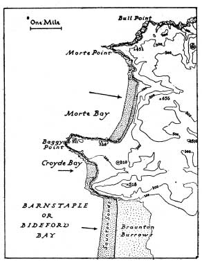
FIG. 22.—An Atlantic Coastline with shingle beaches and sand-dunes at right angles to dominant wave direction (shown by the arrows). Rocky, hilly headlands separate the bays and indicate the east-west strike of the rocks.
Around the shores of Britain there are some remarkably large areas of silt and mud covered only at high tide. Around parts of the Wash high and low tide marks may be several miles apart and the same is true of parts of the Thames estuary, the Bristol Channel, Morecambe Bay and Solway Firth. In these areas there is a steady accretion to the land and the salt-marshes which are developed exhibit the well-known zonation of their vegetation. Reclamation of such areas goes on steadily round many parts of the coast: when the silting has gone on so that the mud-flats are covered only by the higher tides, they are enclosed by earth banks and at first water let in at high tides is allowed to deposit more mud and then to run off gently. Then the entrance of salt water is later prevented and gradually rain water washes the salt out of the soil so that fresh-water marsh replaces salt marsh. After some eight or ten years the ground is sufficiently free from salt for ploughing to be possible.
Such are the features associated respectively with erosion coasts and coasts of accretion. There are other features associated with eustatic movement of elevation or depression. A rising coast frequently shows raised beaches—wave-cut platforms on which rest gravels, sands and other beach- or shallow-water deposits and which are frequently bounded on the landward side by lines of old or “fossil” cliffs. Such raised beaches are well seen round many parts of Britain ; especially famous are the examples along the Clyde estuary. Along the rocky coast of Cornwall the raised beaches are but narrow platforms cut in the hard rocks. Of other striking examples from Scotland one has been chosen for illustration in Plate XI.
A sinking coast or drowned coastline is often highly indented for the sea naturally invades the mouths and lower sections of river valleys and runs up the valleys of tributary streams. Excellent examples are seen along the south coasts of Devon and Cornwall, as illustrated in Plate 26. Local features such as submerged forests are indicative of a sinking or a sunken coastline. A fascinating little book by the late Clement Reid on Submerged Forests described the very numerous examples round the British Isles. Summer visitors perhaps know best those along the coasts of East Anglia and Lincolnshire, West Cornwall or Cheshire.
A distinction is frequently drawn between the “Atlantic” and “Pacific” types of coastline, so-called because of their relative prevalence round those two oceans respectively. In the Atlantic type the “grain” of the country, the axes of the folds in the rocks, is at right angles to the dominant direction of the coast.
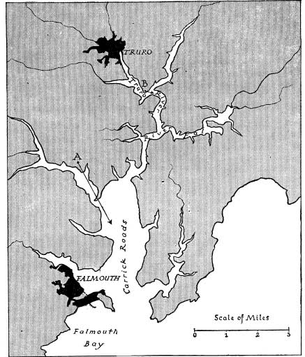
FIG. 23.—A Drowned Coastline The view shown in Plate 26A is taken from the point A, looking in the direction of the arrow ; the view in Plate 26B is from the point B.
This is beautifully seen in north Cornwall where the Armorican folds have east-west axes whereas the coast often trends more nearly north and south. Banks of resistant rock run out to sea as headlands or ridges of rocks and between them are the secluded bays which form such a delightful feature of the coast (Plate 3B). The same phenomenon is seen on a larger scale in south-west Ireland, where the hill ridges of Old Red Sandstone are separated by long narrow rias. In the Pacific type of coastline, less commonly seen in Britain, the coast is roughly parallel to the grain of the country. This may be illustrated from the part of the Dorset coast shown in Plate XXVI.
We have referred to the continental shelf and are perhaps little concerned with what happens beyond its edge. The continental slope to the depths of the open ocean are often very steep—so steep that deposits laid down may slide in great masses from the margins of the shelf to the deep ocean floors and give rise to phenomena of extensive slip faulting and puckering which some geologists claim recently to have recognised in the rocks of past geological ages.
CHAPTER 7
THE SCENERY OF THE SEDIMENTARY ROCKS
THE GREATER part of Britain is made up of rocks which were laid down under water as sediments. They were originally deposited in almost horizontal layers or strata and when first raised up above the level of the sea they were approximately horizontal. Some have remained so, but for the most part they have been tilted and folded to a greater or lesser extent. Interbedded with the sedimentary rocks proper are limestones, as well as lava flows and beds of volcanic ash. Whilst some limestones are built up of fragments of shells and are thus sediments, others are of the nature of chemical precipitates and again others are coral reefs which have grown in situ. Hence the distinction from sediments proper.
Whilst some of the members of the sequence retain the same general characters through a great thickness—the Chalk, for example, in places is nearly 1000 feet thick—it is a common feature for strata of different types—clays, shales, sandstones and many others—to succeed one another with almost bewildering rapidity so that each bed may be only a few feet, or even a few inches, in thickness. This is of great importance since each bed may, and usually does, differ in its resistance to atmospheric and other forms of weathering. It is this variation in ability to stand up against the denuding forces of nature which is largely responsible for the intimately varied scenery of so much of Britain and the absence of monotony even in the lowlands. It is also largely responsible for the remarkable and rapid variations in the sea coasts of the British Isles.
Before considering the land forms which are characteristic of the sedimentary rocks it will be well to recall a few of the salient features of the rocks themselves. The majority show evidence of bedding planes, indicating that they were deposited in layers. This is generally true of the harder rocks such as the sandstones, but bedding planes may be absent in the clays which form an amorphous mass. A few sands and sandstones which were deposited in shallow waters under the influence of currents have a curious type of bedding consequent upon current action and hence known as current bedding or false bedding. It is best understood by reference to the picture, Plate 10 and the diagram Fig. 37.
The bedding planes tend to form planes of weakness along which the rocks split easily. When a hard sandstone splits easily in this way it is known as a flagstone. Because of this property the Caithness flagstones of Old Red Sandstone age were the favourite paving stones for London and other cities till the introduction of artificial stone for the purpose. Some rocks break into such thin slabs that they can be used for roofing and though true slates have a different origin such “slates” as those of Stonesfield and Collyweston are actually thinly bedded limestones. The vogue for “crazy paving” in gardens has introduced many townsmen to a considerable variety of rocks which split easily along the bedding planes. Rocks which do not split more easily along the bedding planes than in other directions are referred to by masons as “freestones” because they are freely worked into building blocks. Even so, as the expert knows, if a freestone block is laid on its edge it is liable to weather more rapidly than if placed as it was quarried. The term freestone is applied both to sandstones and to limestones.
In addition to this character of planes of weakness parallel to the bedding, the majority of the harder rocks have cracks or planes of weakness at right angles to the bedding along which they split easily or along which they are easily attacked by denuding agencies. These planes are known as joints or joint planes and there may be more than one series. In the latter case the major series is known as that of the master joints. When a rock such as a hard sandstone is well jointed it often weathers into vertical crags—a feature exhibited to perfection by the Torridonian Sandstones of the north-west of Scotland (Plate IB). The craggy sandstone cliffs of such heights as Stac Polly afford interesting plant and animal habitats. Although the jointing in limestone is partly of a different origin, being due to some extent to solution of the rock, the effect is broadly the same (Plate 6). Very naturally jointing and bedding both influence to a great extent the character of sea-cliffs and river cliffs. A well-developed system of joints results in vertical cliffs ; where there is at the same time a dip of the rocks seawards or riverwards the combination of circumstances is such as to encourage the detachments of great blocks and the creation of landslides.
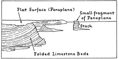
FIG. 24.—Diagrammatic Explanation of the Peneplanation shown in Plate 5A A typical example of submarine peneplanation, with a subsequent uplift of the whole surface. As a result the almost level surface of the ground is independant of the underlying geological structure.
Sedimentary rocks when laid down are almost horizontal so that the simplest case to consider is when horizontal strata are raised up and subjected to denudation. Rivers cut into them and between the young
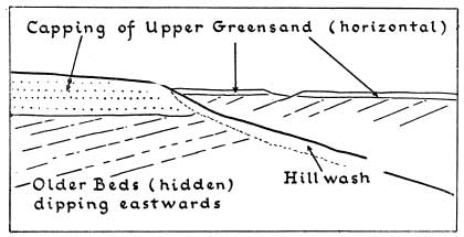
FIG. 25.—Diagrammatic Explanation of the Flat-topped Hills of Plate 5B In contrast to Fig. 24, the flat tops of the hills here follow the bedding of the underlying Upper Greensand which rests almost horizontally, but unconformably, on underlying rocks which dip to the east.
Конец ознакомительного фрагмента.
Текст предоставлен ООО «ЛитРес».
Прочитайте эту книгу целиком, купив полную легальную версию на ЛитРес.
Безопасно оплатить книгу можно банковской картой Visa, MasterCard, Maestro, со счета мобильного телефона, с платежного терминала, в салоне МТС или Связной, через PayPal, WebMoney, Яндекс.Деньги, QIWI Кошелек, бонусными картами или другим удобным Вам способом.
Вы ознакомились с фрагментом книги.
Для бесплатного чтения открыта только часть текста.
Приобретайте полный текст книги у нашего партнера:
Полная версия книги
Всего 10 форматов

