Полная версия:
Etnography of North Russia and Hyperborea
The patronymic form of the names of the tribal unions is confirmed in the legends recorded by Nestor: the Radimichi descend from a certain hero Radim, who brought them to Sozh «from the Lyakhes».
Thus, the main process of widespread settlement of the Pre-Slovens falls for the time after the existence of the Skolot unity. Therefore, the original, toponymic names of tribal unions (and the unions themselves, of course) can be dated to the first half or middle of the 1st millennium BC.
If archeology helped to clarify the boundaries of tribal unions for the time of their withering away (X – XII centuries AD), then it is quite natural to turn to archaeological data to determine the territories of tribal unions of the era of their inception.
Considering the local variants of the Trzhinets-Komarov culture of the primary Proto-Slavs and comparing them with the location of the Slavic peoples (tribal unions) near Nestor, we find a number of geographical coincidences for the main tribal groups.
Moreover, attracting local variants of the Skolot-Lusatian archaeological sites of the 6th – 4th centuries BC, we will see the same picture: local variants of this era also correspond to the location of the Nesterov peoples and their list coincides with the list of variants of the Trzyniec culture… The stability of geographic groups over a whole millennium deserves attention. The names of the unions could change at different times.» (Rybakov B. A. Kievan Ruse and Russian principalities of the XII – XIII centuries. M. Science. 1982). (Note that the ethnonym «Severa» is known as «Severyane» (among the settlers to the Balkans), the Krivichi are also known as «Krivi» and «Kriviteni» (they include «Polochane» along the Polota River and «Smolyane»).
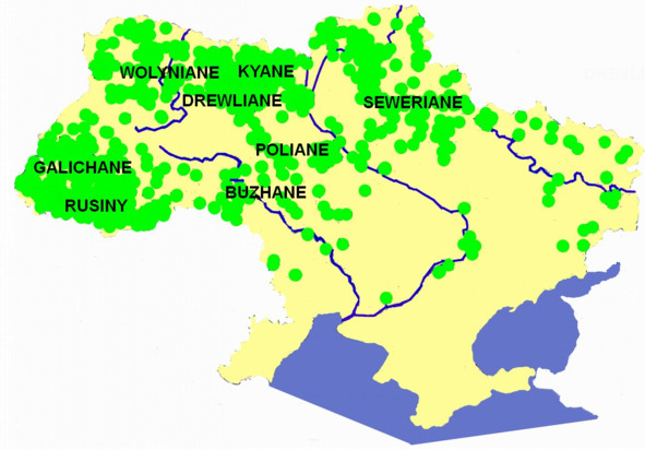
Speaking about the Slavic peoples (unions of tribes), B. A. Rybakov attributes their formation to two eras: he associates the names of the type «Radimichi» with the later colonization of the 6—7 centuries, and the names of the type «Polyane» with the Trinecko-Komarov culture.
«B. V. Gornung speaks even more definitely about the isolation of the Proto-Slavs in the middle of the 2nd millennium BC and directly connects the Proto-Slavs with the Trzhinetsk and Komarov (a more developed version of the Trzyniec) cultures.
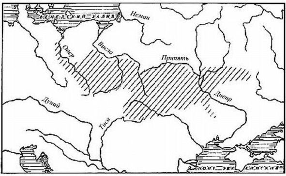
The vast area of Trzyniecki culture in its final form again revived the idea of the Slavic massif from the Dnieper to the Oder, in full agreement with the latest linguistic data on the time of the separation of the Slavs…
B. A. Rybakov. Proto-Slavs in the Bronze Age (Trinecko-Komarov culture 15—13th centuries BC)
Thus, we can recognize the area of the Trzhinets-Komarovo culture as the primary place of unification and formation of the first spun off of the Proto-Slavs, who remained in this space after the grandiose settlement of the Indo-Europeans – the «cords», calmed down. This area can be designated by the somewhat vague word «ancestral home»… Let us consider the duration of the historical life of each of the cultures, reflected by three maps: Trinecko-Komarovskaya – about 400 years, Przeworsko-Zarubinetskaya – about 400 years, Culture Prague-Korczak – about 200 years. As a result, we get about a thousand years, when the area of a certain ethnic community, reflected on these maps, was a historical reality. We involuntarily have to reckon with this and conform to this reality our research in the field of Slavic ethnogenesis.» (Rybakov B. A. Paganism of the Ancient Slavs. M. Science. 1981).
«The creation of a homogeneous archaeological (Trinecko-Komarov) culture was the result and material expression of the consolidation process. The Slavism of that time was not absolutely monolithic – a single archaeological culture was subdivided into 10—15 local variants that could correspond to ancient tribes or tribal alliances, and possibly to the primary dialects of the Proto-Slavic language (?).
The starting point of reference for the Slavic historical process that we have chosen is the middle of the 2nd millennium BC – finds the Proto-Slavic world at the level of the primitive communal system, but with a fairly rich historical past: the ancestors of the Slavs already from the V – III millennia BC knew agriculture, experienced a temporary rise in the Eneolithic era associated with the strengthening of pastoralism, took part in the settlement of huge spaces and by the time of the crystallization of the Proto-Slavic ethnic group, they had already reached a certain level of culture: their economy was based on settled cattle breeding and agriculture with hunting and fishing as supplements; they settled in small villages. The main tools were also made of stone, but bronze was also used (chisels, awls, ornaments). The separation of the druzhina stratum within the tribe is not documented.» (Rybakov B. A. Kievan Ruse and the Russian principalities of the XII – XIII centuries. M. Science. 1982).
Komarovskaya culture dates back to 1500—1200 BC or 16—8 century BC, the Zachinets culture dates back to the 15—12th century BC (Archeology of the USSR. The era of the bronze of the forest belt of the USSR. M. Science. 1987).
Let us now turn to the Russian North. We have such sources as «Stepennaya book» and «Biographies of Stephanie of Perm», which preserved the ethnonyms of the peoples who lived here in the 14th century.
So «Stepennaya book» in the «13th degree» calls: «These are the names of foreign-language countries and places living near Perm: Dvinyane, Ustyuzhane, Vilezhane, Vychegzhane, Penezhane, Yuzhane, Seriane, Gangane, Vyatchane, Lop, Korela, Yugra, Pechera, Vogulichi, Samoyad, Pertasy, Great Perm, Gamal, Chyusovaya.»
«Biography of Stephanie of Permsky» reports: «The names of places and countries and lands of foreign languages living in Perm and around Perm: Dvinyane, Ustyuzhane, Vilezhane, Pinegzhaen, Yugzhane, Syryane (Seriane), Gainiane (Gayane, Guyane), Vyatchane, Lop, Korela, Yugra, Vishera, Pechera, Vogulichi (Vogulitsy, Gogulichi), Samoyad, Pertasy, Great Perm the verb Chusovaya (Михайлов М. Описание Усть-Выма. Вологда.1851).
Let us note the identity of these two lists, in which the Ustyuzhans, the Dvinyans, and the inhabitants of Pechora, and the people of the «Gangan» or «Gainyans» in the upper reaches of the Kama River are named among the peoples foreign to Stephen of Perm.
Some authors believe that the Lop lived along the Lopve River, a tributary of the Kos, or in the Slobodsky district near the village of Lopari. Rivers named Lop-yu, Lop-va are found in the Northern Urals. But the lobe is indicated adjacent to the core. Korel in the 14th century is placed on the Karelian Isthmus and in the adjacent part of Finland (Vyborg province). Near them, in Zaonezhie, back in the 17th century, there were Lop churchyards. Karelians are unknown in Perm. And Pertas will be stirred up in the south of the Komi-Permyak district.
Note that not only Voguli and Korela, but also Dvinyans, Ustyuzhans, Vilezhans, Vychegzhans, Penezhans, Southerners, Vyatchans, who are now considered Russians, are classified as «foreign-speaking countries and places». In a number of lists the Gangan (Gainyan) is replaced by the Galicians. Alexander Gvagnini in 1581 in Verona wrote about the Ustyug region «they have their own language, although they use Russian more» (Известия Архангельского общества изучения Русского Севера. Архангельск. №1. 1911).
Perhaps in the 14th century, separate, independent Slavic languages existed in these lands. V. I. Dal wrote: «The speaking of the Vyatchan people first advised me about the origin of the Bulgarian consecutive member, which, having produced it from Greek; particles „ot, at, to, ta, te“ are applied on Vyatka not indifferently, but by kind…» (Даль В. И. Толковый словарь живого великорусского языка. Т. I – IV. М. 1978. p.LVIII). Either the North Russian dialects sounded alien to the author of the text.
Of other ethnonyms, not foreign-language, but Russian, they are known along the Vage River – «Vazhane», along the Emtse River – «Emchane», along the Nizhnyaya Toyma River – «Kachemyane», along the Onega River – «Onezhane», along the Sysola River – «Sysolyane», «Vologzhanу» (population of Gryazovets, Kadnikovsky and Vologda districts),«Galicianу» (in Galician districts),«Zaonezhanу» (in Zaonezhie).
In the Yarensky district, along the Vym river – «Vymichi». In the Solvychegodsky district, along the rivers Toimam – «Toyimichi». In the Pinezhsky district, along the Sura river – «Sura». Along the Sysola River – «Uzhgovites».
Along the Vahe river – «Shenkurtsy» (the lower course of the Vagi river), «Kuloitsy» (along the Kuloi river), «Kokshary» along the Kokshenga river (a tributary of the Vagi). Among the kokshars, the «Illezanу» stood out along the Ileza River.
Ethnonyms on "– yana»
In the North, ethnonyms in "-an» or "-yane» constitute a single, well-defined array. This massif has no direct connection with the common Slavic (Zhashinetsko- Komarovsky) massif. However, it repeats the path of development of the all-Slavic massif. Based on this, it can be assumed that its emergence belongs to the early period of the Zashchinets-Komarovo culture (16th century BC) with which it was a single whole. Later, after 10—7 centuries BC their connection was lost.
S. V. Sokolovskiy, speaking about topo- and hydronymy as indicators of ethnic areas, notes the need to use the category of toponyms-migrants, «marking the processes of ethnic settlement». As essential features of mass colonization toponyms, S.V. Sokolovsky calls the lack of connection of their etymologies with the names and nicknames of persons, as well as the areality of the topoformants that make up their composition. He notes that: «the last feature is the most significant, since it indicates the transfer of not an isolated name, but a toponymic system.» (Sokolovsky S.V. The role of onomastics data in historical and anthropological research. SE. 1985. No. 5.).
As V. Georgiev noted: «Geographical names are the most important source for determining the ethnogenesis of a given area. In terms of sustainability, these names are not the same: the most stable are the names of rivers, especially the more significant. Small rivers 20—50 km long are unstable. Rivers over 100 km long retain their ancient names. (Georgiev V. Studies in comparative historical linguistics. M. Izd. Foreign literature. 1958)
Let’s try to find a topoformant-indicator of ethnic areas, marking the process of ethnic settlement. V. N. Toporov and O. N. Trubachev point to the extreme conservatism of hydronymic suffixes. On the territory of the settlement of the Slavs, the most ancient names are those in which the suffixes "-n-», "-itsa» are present.
V. A. Nikonov writes: «From the formants that directly formed the nouns (and not adjectives), the ancient “-ets» and “-itsa»… But in toponymy they still differ in many respects… In the old Slavic territories, "-ets» (and "-shevets») forms more than 1/3 of all names of settlements (for example, in the region of Cakovec in northwestern Croatia). In the "-ats» form he is very strong in most of Serbia and Croatia… In Russia, the names with the suffix "-ets» are denser, the more ancient the Slavic settlement is. So, in Ivano-Frankivsk, Chernivtsi and Ternopil regions of Galicia, they now account for more than 3% of the names of settlements, in Vinnitsa and Khmelnytsky 1.5%, in Dnepropetrovsk, Kirovograd, Odessa, Nikolaev – a small fraction of a percent, in Kherson they are not at all. Among hydronyms, the trend is the same. In the Prut and Seret basins, names with the suffix "-ets» own 12% of the names of rivers, in the Upper Donets basin – 5%, in the Seversky Donets basin – 2.5%, in the Azov region less than 1%. In general, the distribution of the formant – “-itsa» is similar. Almost 25% of all hydronyms in Slovenia are formed with this suffix. In the basins of the Prut, Seret and the upper reaches of the Dniester, they account for more than 10% of hydronyms, in the Desna basin 4%, Seversky Donets – less than 2%, south of Khortytsya there are none at all. Among the names of settlements in southwestern Bulgaria (Blagoevgrad region) there are 15%, in Chernivtsi region more than 4%, in Poltava 0.6%. They were ametal in the Russian north-west, especially in Pskov and adjacent lands. (В. А. Никонов. Введение в топонимику. М. Наука. 1965).
On the territory of the Smolensk region, the word-formation suffix "-itsa» has more than two dozen river hydronyms, including Belitsa, Velitsa, Dolzhitsa, Ilzhitsa, Petritsa, Uzhitsa, Chernitsa, Shuytsa, etc.
V. N. Toporov and O. N. Trubachev point out: «The suffix "-itsa» is a characteristic all -Slavic hydronymic format and is widely represented in all old Slavic territories. On the one hand, such ancient formations as Vislitsa…, on the other hand, such obviously late formations as Michalkitsa… The widespread use of the suffix "-itsa» for a long time, as well as other formants with the old "-k-" in hydronymy, is especially noteworthy, since for the old European hydronymy, excluding the Celtic territory, the use of the suffix "-k-" was not characteristic…
Speaking about the features of the geographical distribution of hydronyms on "-itsa» in the Upper Dnieper region, it should be specially noted that, in contrast to most of the cases considered so far, there is a clear predominance in relative terms of hydronyms of this type in the Berezina basin (slightly less than 1/6 …), in the Prytpyat basin (although in its upper reaches on the left side there are few names for "—itsa», but on its tributary Ptichi, just like on the Berezen, 1/6 of all names contain the suffix "—itsa»). In the area lying to the east of the main pivot of the Dnieper, the uppermost part of the Dnieper to Smolensk stands out with a large number of names for "-itsa», adjacent to the left tributaries of the Western Dvina, as well as the upper reaches of the Desna and Iput. Of course, there are a lot of names in "-itsa» on Sozh, however, here they do not constitute a noticeable component of hydronymy in comparison with other formations.
When considering the distribution of hydronyms to "—itsa» outside the Dnieper basin, two points should be emphasized: firstly, a large number of hydronyms in the upper part of the Western Dvina (… at least 30 …); secondly, these names are quite numerous along the Dniester and the Southern Bug, where there are about fifty of them.». (В. Н. Топоров, О. Н. Трубачев. Лингвистический анализ гидронимов Верхнего Поднепровья. Изд. АНССР. М.1962).
There is no word-formation suffix "-itsa» in Siberia.
You can compare the spread of hydronyms to "-itsa» and archaeological cultures. Until recently, this was almost impossible to do. There was no material for comparison on a sufficiently large territory, well studied archaeologically and with a representative sample of topo- and hydronyms. After the Glossary of Guides of Ukraine was published in 1979, including 44 thousand variants of the names of rivers and lakes, it became possible to make such a comparison. By mapping hydronyms with the suffix "-itsa» we compared the resulting area with a map of archaeological cultures for coincidence. And such a match was found. The area of hydronyms with the suffix "-itsa» coincided with the area of the Trzhynec-Komarov culture, moreover, the hydronymic map shows a break in a single massif along the borders of the Komarov and Trzhinets cultures. (Словник гідронімів Украіни. Киев. Наукова Думка. 1979).
Then, if B. A. Rybakov’s conclusion about the identity of the areas of ethnonyms in "-ane» or "-yane» and the Tshinetsko-Komarov culture, as well as our conclusion about the identity of the areas of hydronyms to "-itsa» and Trinecko-Komarov culture are true, then the areas of ethnonyms in -an or -yane and hydronyms in "-itsa» must coincide. And they match. The overlap of areas should also be observed in the Russian North.
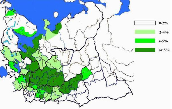
Hydronyms of Ukraine on "-itsa»
We have analyzed about 32 thousand variants of hydronyms of the Russian North and adjacent territories for the presence of hydronyms for "-itsa». There are about 1300 such hydronyms. It should be noted that almost all hydronyms have a Slavic root base. As well as in the Vistula basin, there are hydronyms associated with names among them. This indicates either the continued participation in word formation of the suffix "-itsa», at least until the 18th century. Or about the rethinking of incomprehensible words by the local population. At least the variants of writing hydronyms in the scribal acts of the 15th century and in the 20th century testify in favor of this version.
Regarding the spread of hydronyms to "-itsa», one must take into account the fact that rivers crossed the boundaries of administrative entities and therefore, the real independent number of hydronyms in areas with a small number of identified ones is much less. In the Vyatka province, borders were drawn along watersheds, and if there are 70 hydronyms in the Oryol district with "-itsa», and in Slobodskoy district 53, then in Yaransky and Nolinsky there are 2 each, but in the Urzhum district they are not.
In addition, the hydronym Talitsa, formed from the term denoting a temporary watercourse that existed during the spring flood, but became permanent over time, is found almost everywhere (at least in a single amount).
The largest percentage of hydronyms for "-itsa» is observed in the following northern counties: Kadnikov 12%, Totema 12%, Nikolsk 11%, Velikoustyug 9%, Velsk 9%, Arkhangelsk 8%, Vologda 7%, Onezhsk 7%, Pritimanye 6%, Kargopol 5%. In the adjacent territories: Orlov 14%, Vyatka 9%, Slobodskoy 7%, Chukhloma 7%, Kirillov 6%, Kologriv 6%, Kotelnich 6%, Soligalich 6%, Kineshema 5%.
Thus, Posukhonye and middle Vyatka are comparable to the Prut and Seret basins, the rest of the territories are with Central Ukraine.
The Desna basin (4—5%) is comparable to the northern districts and territories: Gryazovets, Petrozavodsk, which were part of the Dvina district – Pechenga and Tersky coast. In the adjacent territories: Belozersk, Bui, Galich, Kostroma.
The following northern districts are comparable with the Seversky Donets basin (2—4%, focal Old Slavic colonization): Vytegra, Mezen, Povenets, Solvychegodsk, Kholmogory, and Shenkursk. In the adjacent territories: Varnavin, Vetluga, Lyubim, Makariev, Poshekhonie, Ustyuzhna, Cherepovets.
There are practically no hydronyms for "-itsa» (up to 2% or less than 3 hydronyms) in the following northern districts and territories: Danilov, Kem, Kola (Imandra, Kola and Murmansk coast, Ponoy), Lodeynopolye, Mezen (Verkhnyaya Mezen), Olonets, Pechora, Pinega, Pudozh, Ust-Sysolsk, Yarensk. In the adjacent territories: Berezov, Verkhotursk, Glazov, Mologa, Nolinsk, Solikamsk, Turinsk, Urzhum, Cherdin, Yaransk.
Let us now consider the ratio of hydronyms to "-itsa» and ethnonyms to "– yane».
Arkhangelsk district (8%) – Dvinyane. Here you can also include the Tersky coast and Kholmogorsky district.
In the Kholmogorsk district, hydronyms are adjacent to Emtse (Emchane).
Veliky Ustyug district (9%) – Ustyuzhane.
Nikolsky district (11%) – Yuzhane. Vilezhane and Vychegzhane, most likely local groups of Ustyuzhan or Yuzhan, living in the area of Solvychegodsk and Lalsk.
Orlovsky (14%), Vyatsky, Kotelnichsky districts – Vyatchane.
Slobodskoy uyezd (7%) – Seriane and Gangane. It should be noted that in the northern part of the Komi-Permyak district, near Gain, most of the hydronyms with the suffix "-itsa» of the Cherdyn district are concentrated, their percentage reaches more than 5%.
Kologrivsky (7%), Galichsky, Chukhlomsky, Soligalichsky districts (in the 16th century were one region) – Galiciane.
Onega (7%), Kargopolsky, Kirillovsky districts (in the 16th century they constituted the Onega region) – Onezhane.
Kadnikovsky (12%), Vologda, Gryazovets districts (in the 16th century were one region) – Vologzhane.
Velsky uyezd (9%) – Vazhane (group – Ust’yane).
The local maximum of hydronyms for "-itsa» in the Olonets province has a correspondence in Zaonezhany – Russians of Zaonezhie (centered in Kizhi).
The situation with Pritman’e is not entirely clear; no Russian ethnonym has been recorded for this area, and according to cartographic material (V. Kord.
Materials on the history of Russian cartography. Kiev. 1899) it can be located both in Ugra and Pecher. Perhaps the ethnographic group of dvinian lived here. The ethnonym of the population of Totemsky district is also unclear. The inhabitants of Totma themselves are totmichi, but on all sides the district bordered on vologzhans, galitshans, vazhans, yuzhans and ustyuzhans.
As for areas comparable to the Seversky Donets basin, then the example of the Shenkursk district is typical. Occupying the lower reaches of the Vagi River, it, unlike the upper reaches of this river, has a minimum percentage of hydronyms with the suffix "-itsa», and the population is represented by the ethnonym – Shenkurts, in contrast to Vazhan in the Velsk district in the upper Vaga.
Of interest is the ethnonym Penezhan or Pinegzhan. In Pinezhsk (formerly Kevrola) uyezd, hydronyms for "-itsa» are less than 1%. Therefore, it can be assumed that the ethnonym Penezhane belonged to the population group of the upper Pinega in the Solvychegodsky district, which was part of the Ustyuzhan people.
In places of settlement of lopa, Korela, Vogulichi, samoyadi, Pertases, Vishera, and in Perm Velikaya (Chusovaya), there are practically no hydronyms for "-itsa».
In general, there is a coincidence of the areas of distribution of ethnonyms in "-an» or "-yana» and the areas of hydronyms with the suffix "-itsa». Based on the fact of their appearance and development during the Tszyniecko-Komarov culture (15—8 centuries BC) the presence of the Proto-Slavic (Old North Russian) population in the North of Russia in the same period can be considered established.
Given the presence in the Russian North of hydronyms with more ancient formants (for example, "-na») you can also assume that its Proto-Slavic population did not appear as a result of external colonization in that era, but was the local autochthonous population.
Hydronyms for "-itsa»
Archaic hydronymy and the population of the Russian North during the Mesolithic-Neolithic era
In our works devoted to the problem of the settlement of the Slavic population in the north of Europe, the Old Slavic and Old Indo-European hydronymic layers attributed to the era of the Tshinetsko-Komarovo culture (16—8 centuries BC) and the Trypillian culture (5500—2650 BC) were identified respectively.
Among hydronyms, a group of names was identified consisting of root bases that do not have suffix formants. The specified group of hydronyms definitely refers to the Slavic languages, or rather to Russian. It is impossible to assign them to the time after the appearance of the suffixal formants "-na», "-itsa», which are considered the most ancient on the territory of the settlement of the Slavs. (V. N. Toporov, O. N. Trubachev. Linguistic analysis of hydronyms of the Upper Dnieper region. Publishing house ANSSR. M. 1962).
This is confirmed by the presence of variants with the formants "-na», "-ma», "-ga» simultaneously with the root variants, for example: Tyulen’-ga, Morzh-yu (Kholmogorsk district);
Yozh-ma, Yezhu-ga, Koval’-ga, Chashko-ma (Pinezhsky district); Yel-ma, Yel’-ma-nga, Olen-ga, Sig-ma (Kemsky district); Pechen’-ga, Pechen’-rechka (Murmansk region).
S. V. Sokolovsky, speaking about topo- and hydronymy as indicators of ethnic areas, notes the need to use the category of toponyms-migrants, «marking the processes of ethnic settlement». As essential features of mass-colonization toponyms, S.V. Sokolovsky calls the disconnection of their etymologies with the names and nicknames of persons, as well as the areality of the topoformants included in their composition. He notes that: «the last feature is the most significant, since it indicates the transfer of not an isolated name, but a toponymic system.» (Соколовский С. В. Роль данных ономастики в историко-антропологических исследованиях. Советская этнография. 1985. №5.).

