Полная версия:
Southern England

Collins New Naturalist Library
108
Southern England
Peter Friend

Editors
SARAH A. CORBET, ScD
PROF. RICHARD WEST, ScD, FRS, FGS
DAVID STREETER, MBE, FIBIOL
JIM FLEGG, OBE, FIHORT
PROF. JONATHAN SILVERTOWN
The aim of this series is to interest the general reader in the wildlife of Britain by recapturing the enquiring spirit of the old naturalists.
The editors believe that the natural pride of the British public in the native flora and fauna, to which must be added concern for their conservation, is best fostered by maintaining a high standard of accuracy combined with clarity of exposition in presenting the results of modern scientific research.
Table of Contents
Cover Page
Title Page
Editors
Editor’s Preface
Picture Credits
Author’s Foreword and Acknowledgements
CHAPTER 1 Looking at Southern England’s Landscapes
CHAPTER 2 Time, Process Southern England’s Landscapes
CHAPTER 3 Movement of the Earth’s Surface from Within
CHAPTER 4 The Southwest Region
CHAPTER 5 The South Coast Region
CHAPTER 6 The Severn Valley Region
CHAPTER 7 London and the Thames Valley Region
CHAPTER 8 The East Anglia Region
CHAPTER 9 The Making of Southern England
Further Reading
Index
The New Naturalist Library
About the Author
Copyright
About the Publisher
Editor’s Preface
L. DUDLEY STAMP’S Britain’s Structure and Scenery was one if the earliest books of The New Naturalist Library, published in 1946. Repeated . later editions in the period to 1986 testified to the success of his approach towards providing a geological framework for understanding Britain’s landscapes and natural history. He began his account in these words: ‘The wealth of a country’s fauna and fauna and flora is not to be measured by numbers of species alone. Its wealth lies rather in variety, and to a naturalist in the British Isles, the fascination of the native fauna and flora is in the great variety to be found in a small space.’ This variety has its foundation in the underlying geology and the landscapes which are derived from the geology, as Dudley Stamp described so well. For some time, it has been the ambition of the Editors to approach this subject again, since our understanding of the geology and associated landscape evolution has increased so very significantly in the last few decades. The author, Peter Friend, has had long experience of active field research in geology and landscape in many parts of the world, as well as having an intimate knowledge of the subject in the British Isles. He has been able to take full advantage of modern developments in computer mapping and colour printing, making it possible to present the subject in a novel fashion, with great clarity, following the New Naturalist tradition emphasising the importance of illustration. The individual treatment of regions and areas of Southern England brings to the fore the significance of geology and landscape for naturalists who have local or wider interests at heart, giving a necessary basis for relating biodiversity to geodiversity. These two aspects of natural history have come to be seen to be widely significant in understanding plant and animal distribution as well as the problems of conservation. The book is therefore a very ti mely addition to the New Naturalist Library.
Picture Credits
THE PHOTOGRAPHS and other illustrations that form such a key part of this book have come from many sources, and I am grateful to the following organisations and individuals for kindly allowing me to use their material:
Aerofilms (Figs 133, 232, 249, 252, 256, 258, 259, 261, 270, 280, 309, 312)
British Geological Survey (Figs 152, 284)
Cambridge News (Fig. 233)
Cambridge University Collection of Air Photographs (Figs 25, 118, 120, 243, 253, 282, 300, 310)
Cassini Publishing (Figs 26, 27)
Sylvia Cordaiy Photo Library (Fig. 141)
Robert Harding Picture Library (Fig. 313)
English Heritage (Figs 83, 308)
Landform Slides – Ken Gardner (Figs 17, 18, 43, 55, 70, 75, 76, 85, 88, 104, 161, 162, 165, 195)
Landform Slides – John L. Roberts (Fig. 69)
Last Refuge Ltd – Adrian Warren, Dae Sasitorn and Will Brett (Figs 41, 42, 46, 47, 53, 54, 56, 58, 60, 62, 63, 67, 68, 71, 72, 73, 74, 82, 86, 89, 90, 91, 101, 102, 103, 108, 110, 111, 112, 119, 121, 122, 125, 130, 132, 134, 135, 142, 144, 146, 148, 158, 163, 164, 169, 171, 175, 176, 185, 191, 192, 193, 194, 196, 216, 217, 218, 219, 220, 222, 254)
London Aerial Photo Library (Figs 23, 199, 205, 207, 235, 257, 277, 297, 298, 303, 314)
Norfolk Museums and Archaeology Service – Nick Arber (Fig. 16)
Norfolk Museums and Archaeology Service – Derek A. Edwards (Figs 1, 287, 293, 301, 302, 306, 307, 315)
Network Rail (Fig. 145)
Peter Oliver, Herefordshire and Worcestershire Heritage Trust (Fig. 172)
Mike Page (Fig. 311)
Science Photo Library (Fig. 2)
Sedgwick Museum, Cambridge (Fig. 239)
R. C. Selley – Petravin Press (Fig. 202)
Sheila Smart (Fig. 131)
Suffolk County Council (Fig. 255)
Victoria & Albert Museum (Fig. 250)
Illustrations that do not have a source credited in the caption are my own work, or that of the team working with me at the Department of Earth Sciences in Cambridge.
Author’s Foreword and Acknowledgements
MOST PEOPLE ENJOY SCENERY. In my case, an enthusiasm for exploring the countryside was learnt early on from my parents, and my career as a geologist has since allowed me to explore landscapes from the Arctic to tropical deserts and jungles. My hope is that this book will help more people to enjoy the countryside by bringing together some of the exciting recent discoveries about our Earth.
Landscapes are easy to look at, but difficult to describe in words. Recent developments in computer technology offer powerful ways of analysing and presenting landscapes using maps, diagrams and photographs, and it is this imagery that forms the core of this book. Developing the imagery has been the main role of a succession of enthusiastic helpers. Lucinda Edes, Emilie Galley, Liesbeth Renders and Helena Warrington brought their skills and enthusiasm to the early days of the project, working out what could be done best. James Sample has more recently further developed the methods of presentation, and has played a key role in bringing this project to fruition. All have helped to make the project enjoyable as well as productive.
The home for this project has been the Department of Earth Sciences at the University of Cambridge. I walked into the Department as a first-year undergraduate more than 50 years ago and, apart from a period in the Scott Polar Research Institute, I have been based here ever since. I have been teaching and exploring the scenery and geology of many parts of the world, including multiple visits to Spitsbergen, Greenland, Spain, India and Pakistan. This has been an exciting period to be working in geology, particularly in Cambridge, because many key advances have been achieved by the people working here. Apart from the great benefit of being part of this research environment, I have enjoyed the support of six successive Heads of Department and many other colleagues, especially our administrator Margaret Johnston and her team. It has been invaluable to have access to the excellent library run by Ruth Banger and Libby Tilley, and the patient computer support of Jun Aizawa, Aidan Foster, Pete Hill and Pete Wilkins.
I would also like to acknowledge my debt to the Cambridge college system, particularly my own college, Darwin. The College has provided me with the congenial friendship of many people from diverse backgrounds, and their skills have helped me to remain a generalist in my interests.
Any work of this sort on the British Isles owes a fundamental debt to the British Geological Survey (BGS), now based at Keyworth near Nottingham. The numerous Survey maps and reports on this country provide a remarkable source of carefully observed and objective information. The BGS has also readily provided advice and discussion of this project, and helped to determine the sort of coverage and level that would be best.
Many other people have made important contributions by providing ideas and information. These include: John R. L. Allen, Julian Andrews, Muriel Arber, Steve Boreham, Becky Briant, Keith Clayton, Tony Cox, Alan Dawn, Colin Forbes, Brian Funnell, Phillip Gibbard, Steve Jones, Gerald Lucy, Dan Mackenzie, Bob Markham, Charles Notcutt, Bernard O’Connor, Richard Preece, Graham Ward and Richard West.
This book is dedicated to the Dr John C. Taylor Foundation, which has provided the financial support for the project, allowing me to work with such a remarkable succession of talented young assistants. More than 40 years ago, John spent two summers exploring the geology of Spitsbergen with me, and we have remained friends ever since. I am extremely grateful for the help of his foundation during the writing of this book.
CHAPTER 1 Looking at Southern England’s Landscapes
FIRST APPROACHES
THE WORD LANDSCAPE has different meanings for different people, and the best way to illustrate the meaning I have adopted in this book is to look at an example. I have chosen a landscape in the northwest corner of Norfolk, part of our East Anglia Region (Fig. 1).
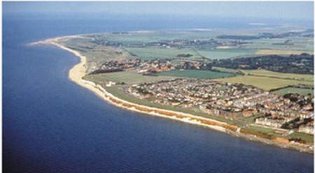
FIG 1. Landscape of the northwest corner of Norfolk. (Copyright Norfolk Museums and Archaeology Service & Derek A. Edwards)
My approach is to focus first on the natural features that we can call landforms, because they have distinctive shapes that directly reflect the processes that formed them. In this Norfolk landscape, coastline landforms are clearly defined but are remarkably varied, ranging from sea cliffs to sandy beaches, gravel spits, wind-blown dunes and salt marshes. Inland, the main features in this photo are the groups of buildings that form the villages and the edge of the town of Hunstanton, and the pattern of fields and woods. All of these are man-made features and are best understood by following the work of landscape historians. My interest is primarily in the natural topography on which these man-made features have developed, because even in this rather flat landscape – and not clearly visible on the photograph – there are gentle hills, valleys and streams that I want to try to understand.
Scale and size in landscapes are important considerations that we will return to frequently. The landscapes that we shall be discussing are generally kilometres to tens of kilometres across, and they are often best examined from the air, or by using computer-based maps with exaggerated vertical scale.
Southern England contains many famous and well-loved natural landscapes, ranging from the Chalk Downs, with their unique flora and fauna, to the rocky promontories and bays of Cornwall, Devon and Dorset. In total topographic contrast, the Fens of East Anglia are regarded by some as representing an extreme absence of any scenery at all, but their remarkable flatness is of interest because they are the result of recent sea-level rise, and of engineering on a remarkable scale. These different landscapes are produced by a wide variety of events and processes; exploring these is the theme of this book.
As we have already seen, landscapes have often been extensively modified by people. The early clearance of woodland and the construction of field boundaries have profoundly changed the scenery and, more recently, the construction of buildings, roads, railways, canals and airports has almost completely covered some areas of Southern England. Figure 2 shows night-time lighting in cities, towns and oil platforms, giving a vivid impression of the present extent and distribution of the larger settlements. It is surprising how varied the population density is, even in crowded Britain. Using the figures for 2002, the population density of the UK overall is 244 people per square kilometre, but this conceals a huge variation: 8 people per square kilometre in the Highland Region of Scotland, 143 for Cornwall, 149 for Norfolk and an amazing 13,609 for Kensington and Chelsea in London.
The main focus of this book is the pattern of large scenic features that have resulted from natural episodes that predate human influence. It is not usually difficult to distinguish the natural from the man-made, and the study of the natural can often explain many aspects of the way our ancestors lived in the landscape. It is possible to uncover the reasons why people have chosen to settle with their families in certain places, why villages have grown by the clustering of houses in particular locations, and why some villages have then grown further and turned into towns and eventually cities. Even the roads, railways and airfields have clearly grown using the valley floors, river crossings, better-drained slopes and plateaus that are part of the natural scenery.
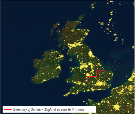
FIG 2. Satellite image over Britain showing artificial lighting at night. (Copyright Planetary Visions Ltd/Science Photo Library)
There is a further enjoyment that people find in landscapes and scenery that is more difficult to understand. Is it just the physical challenge that causes people to walk and climb to the tops of hills, mountains and other viewpoints? Why do people enjoy the work of landscape painters and photographers? Why do so many tourists in cars choose to take ‘scenic’ excursions rather than the shortest routes, and why is the preservation of ‘unspoilt’ or wilderness areas now such a popular cause? It is difficult to understand the various emotions involved, and trying too hard to analyse them may be missing the point. So it seems best to hope simply that this book will help to satisfy some people’s curiosity, and at the same time add to their enjoyment of our natural landscapes.
MAPPING AND ANALYSING SOUTHERN ENGLAND
The detailed discussions of most of the rest of this book have involved dividing Southern England into a number of Areas that form the ‘building blocks’ for the coverage of Southern England (Fig. 3). Each Area is based on a double-page spread of the size used in many of the larger road atlases available for Britain. In this case I have used the Collins Road Atlas, Britain. This means that total coverage of Southern England is provided, and it is easy for the reader to navigate from place to place. At the beginning of each Area description, a location map of the Area and its neighbours is provided. Ordnance Survey (OS) National Grid References are provided for the edges of the Area, in km east and north of the arbitrary OS Grid origin some 80 km west of the Scilly Isles.
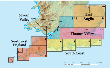
FIG 3. Division of Southern England into Regions and Areas.
For convenient reference the Areas – numbered 1 to 16 – are grouped into five Regions. Each Region forms a chapter and starts with a general introduction:
CHAPTER REGION AREA Chapter 4 Southwest 1 West Cornwall 2 East Cornwall and South Devon 3 North Devon and West Somerset Chapter 5 South Coast 4 East Devon, Somerset and Dorset 5 Hampshire and the Isle of Wight 6 Sussex 7 East Sussex and Southeast Kent Chapter 6 Severn Valley 8 Bristol 9 The Cotswolds and the Middle Severn Chapter 7 London and the Thames Valley 10 The Cotswolds to Reading 11 London 12 The Thames Estuary Chapter 8 East Anglia 13 Northampton to Cambridge 14 Suffolk and North Essex 15 Leicester to the Fens 16 NorfolkEven the Area building blocks are relatively large, with arbitrary boundaries, and it has generally been helpful to discuss smaller areas within and across these boundaries that are based on natural features of the scenery (Fig. 4). I have called these smaller areas Landscapes, because they are characterised by distinctive features, usually reflecting aspects of the bedrock or distinctive events in their evolution.
These Landscapes correspond closely to area divisions of England that were defined by the Government Countryside Agency (www.countryside.gov.uk). This scheme divides England into 159 ‘character areas’ on the basis of natural features of the scenery along with aspects of its human settlement, past and future development, land use and vegetation and wildlife, so they are likely to be familiar divisions to many readers of the New Naturalist series. Other Government agencies (particularly the Department for Environment, Food and Rural Affairs) that administer the funding of land management use the same character area division.
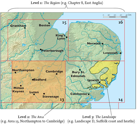
FIG 4. Examples of the three levels of division adopted in the treatment of Southern England.
Maps displaying patterns of elevation of the countryside above sea level are an important part of the discussions. The elevation data on the maps in this book have been compiled and made available as part of the LANDMAP project, which provides a computer-based digital survey of Britain for research and educational use. LANDMAP Digital Elevation Maps (DEMs) are based on satellite radar survey measurements which divide the land surface into a grid of 25 m by 25 m pixels. The average height of each pixel is then measured to produce a terrain model with a vertical accuracy of about ± 5 m. A standard colour shading scale is used to represent heights, ranging from greens for the lowest ground, through yellows and browns, to greys for the highest ground. It is best to use the full range of colours for each map, no matter what numerical range of heights is involved. This makes it possible to convey the fine detail of slopes etc., whether the map is for the Fens or the high moors. To make it possible to compare between maps using this colour scheme, we have quoted the maximum elevation reached in each Area on each map.
I have used ESRI ARC Geographic Information System (GIS) software in the processing and manipulating of the map data. This software makes it possible to present artificial hill-shading, which makes the topography easier to understand, and to provide maps representing slope patterns in certain areas.
In addition, data on roads, railways, coastlines, town boundaries, rivers, etc. suitable for reproduction at a scale of 1: 200,000 has been made available by the Collins Bartholomew mapping agency. For any further details of the areas covered, it is recommended that Ordnance Survey Landranger (1: 50,000) maps are consulted.
LANDSCAPE CHANGE
We tend to think of rural landscapes as unchanging features of our surroundings, in contrast to the man-made scenery of cities and towns. Yet we all know of local catastrophes, such as a sea cliff collapsing during a storm, or a flooding river removing its bank and wrecking the nearby buildings, and these are the sorts of local events that do result in change. Despite the excitement, individual changes of this sort are small and can usually be regarded as local modifications. However, over time, the accumulated effects of many such modifications can cause whole landscapes to change.
Size and time clearly both play key parts here. The collapsed cliff or eroded river bank will probably be tens to hundreds of metres long at most, while the larger landscape features picked out in this book are tens or even hundreds of kilometres across. Noting the length scales involved in this way is an important way of keeping such differences clearly in mind.
Moreover, while local events such as the destruction of landforms or buildings may be immediately newsworthy, more long-term patterns of change in the natural scenery are rarely apparent during the life spans of people, and even during the hundreds of years of written records. So it becomes necessary to use indirect and circumstantial evidence – to play the detective – to find out what long-term changes have been going on.
An important step in thinking about the natural landscape is to look at it in terms of modifications to complex surfaces defined by the ground. On land, we tend to be most aware of erosional processes removing material, but it is important to realise that the material removed has to end up somewhere – and this will involve its deposition later, on land or in the sea. How much material was removed from the cliff during the storm or from the banks of the river during the flood? Where did the lost material go, and how did it change the landscape when it was deposited at its new destination? Knowledge of these surface modifications can provide a yardstick that allows us to compare different sorts of changes happening over different periods of time and at different scales, and can help us to work out their relative importance, quoting amounts and rates. For example, a flooding river may remove a hundred metres of river bank, modifying the local landscape a little in the process. However, this modification is unlikely to have much impact on the scenery, unless followed many, many times by similar modifications, over centuries to hundreds of thousands of years. In this way a series of such floods can erode and move material that, in the long run, may be of sufficient volume to significantly change the landscape, for example lowering a hill slope or filling a valley bottom.
The majority of- but not all – surface modification processes act to reduce or flatten topography, mainly by eroding the higher features but also by filling in lower ground with sediment. So logically landscapes might always be regarded as tending towards a flat surface. Our understanding of the processes involved suggests that any land area with mountains or hills will be eroded downwards to an increasingly flat surface as time passes, although the rate of erosion will reduce as the topography becomes more and more smooth. Acting against these flattening processes are periodic movements of the ground surface caused by forces within the Earth, producing new mountains and hills, and so creating new landscapes (Fig. 5).


